Hurricane Season 2012 Update October 23: Tropical Cyclone Sandy
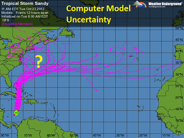
For several days now the meteorological community has been monitoring the western Caribbean Sea for the potential of tropical development. Computer models have been consistent with the idea of certain atmospheric parameters that would fall into place in this region that would be conducive for spawning a tropical system.Yesterday a wave of low pressure over the warm waters of the Caribbean within this ripe atmospheric setting has coalesced to form Tropical Storm Sandy, the eighteenth named tropical system of the 2012 Atlantic Hurricane Season. As of the noon time hour, Sandy is centered approximately 300 miles south of the island nation of Jamaica with a minimum central pressure of 993 millibars and maximum sustained winds of 50 miles per hour. Its movement is to the NNE ever so slowly at 4 miles per hour, because Sandy is situated in such a favorable environment, it is expected to intensify to perhaps hurricane status before making its first landfall over Jamaica. Due to its broad circulation and slow forward speed, this system will produce copious amounts of rainfall over Jamaica, Cuba, and the impoverished nation of Haiti. This could have a devastating affect as these are fairly mountainous nations and are prone to mudslides and flash flooding. As Sandy progresses to the north it will likely loose strength as its center of circulation passes over the mountains of Cuba before re-emerging over the waters of the Atlantic Ocean over the Bahamas, likely regaining some strength there. Thereafter, the path of this system will pose a challenge as several factors could influence where Sandy goes next. Some computer models have this system staying away from the US mainland as its influenced by a weak subtropical jet stream and takes it out to sea. While others indicate that Sandy will be influenced by a stronger polar jet stream, if this happens there would be two possible scenarios depending on the timing of the jet streams' interaction with Sandy. In the first case scenario, Sandy would begin to interact with the jet stream sooner, this would bring its circulation on a close approach to the east coast of Florida by Friday bringing bands of heavy rain and perhaps tropical forced winds to places like West Palm Beach before it re-curves out to the open waters of the Atlantic. In the second and perhaps worst case scenario, Sandy would begin to interact with the jet stream later moving north past the Bahamas and then accelerate on a bee line up the eastern seaboard targeting anywhere from North Carolina to Maine this weekend. In this worst case scenario, Sandy would be absorbed by a storm system with an associated cold front that will be ridding on the jet stream that will be moving east from the Great Lakes. The phasing of these two system has the potential to wreak havoc on the eastern US from the Midatlantic to New England as well as locations inland from the coast in the Northeast as some models suggest. It is important to note that nothing is set in stone, there is little confidence in the forecast at this time to predict what influence, if any, this system will have on the forecast but it does bear watching.
(Computer Model Uncertainty)
Just for fun, lets discuss some of the bizarre details that some computer models are predicting this weekend; continuing on the absolute "worst case scenario" as Sandy begins to interact with this other storm system riding on the jet stream, the two storms will phase with one another just off the east coast of the Midatlantic. A swath of heavy precipitation will break out over the Northeast with gale and storm forced winds from Virginia to New England producing tremendous beach erosion and coastal flooding. Once Sandy becomes completely absorbed by the frontal boundary the entire system will become "negatively tilted" pulling an incredible amount of tropical moisture out ahead of it over New England producing torrential rains and flash flooding; while dragging cold air in on the back side producing a swath of heavy wet snow with thunder and lightning over interior sections of the Northeast and Midatlantic especially over the higher elevations of the Appalachians leading to wide spread powers outages for days. The entire system will then lift north into Canada early next week losing strength as it does so. This would be an historic storm if it pans out this way; as bizarre and highly unlikely as it seems, this has happened before during the super storm dubbed "The Perfect Storm" this time back in 1991 when Hurricane Grace phased with a frontal system ridding on the jet stream just off the east coast causing devastation in the Northeast.
(1991 Satellite Imagery Hurricane Grace Pahses with a Frontal System off the Northeast Coast)
The National Oceanic and Atmospheric Administration, The Weather Channel, The Weather Underground, AccuWeather, WKBW Meteorologist Mr. Aaron Mentkowski, Buffalo State Meteorology Professor Dr. Stephen Vermette.


No comments:
Post a Comment