THE NATIONAL WEATHER SERVICE IN UPTON HAS ISSUED A WINTER WEATHER
ADVISORY FOR SNOW...WHICH IS IN EFFECT FROM 5 PM THIS AFTERNOON TO 6
AM EST THURSDAY.
(Click Image to Expand)

* LOCATIONS...SOUTHERN NASSAU AND SUFFOLK COUNTIES ON LONG ISLAND.

* HAZARD TYPES...SNOW.

* ACCUMULATIONS...SNOW ACCUMULATION OF 2 TO 5 INCHES...HIGHEST
  ACROSS EASTERN LONG ISLAND. THERE IS A LOW PROBABILITY FOR 4 TO
  8 INCHES...ONLY IF HEAVY SNOW BANDING WORKS NORTH INTO THE AREA.
(Click Image to Expand)
* WINDS...NORTHEAST 10 TO 15 MPH WITH GUSTS UP TO 25 MPH.

* TEMPERATURES...IN THE LOWER 30S.

* VISIBILITIES...ONE HALF MILE AT TIMES. THERE IS A LOW
  PROBABILITY FOR ONE QUARTER MILE OR LESS AT TIMES...ONLY IF
  HEAVY SNOW BANDING WORKS NORTH INTO THE AREA.

* TIMING...THIS EVENING INTO TONIGHT.

* IMPACTS...HAZARDOUS TRAVEL CONDITIONS DUE TO REDUCED
  VISIBILITIES AND SNOW COVERED ROADS. THE WORST CONDITIONS ARE
  EXPECTED AFTER THIS EVENING RUSH INTO THE OVERNIGHT. ALTHOUGH
  SNOW IS EXPECTED TO END BY THE THURSDAY MORNING RUSH...ROADS
  WILL STILL BE SNOW COVERED.
Asteroid 2012 DA14 discovered in 2012 by a group of Spanish astronomers is expected to make a close approach to Earth on Friday February 15th 2013. So close in fact that it will pass between the Earth and our Geostationary satellite orbits. The asteroid, on its closest approach, will pass with in 18,000 miles of the Earth's surface making it the closet approach ever observed by NASA since they began monitoring near Earth objects in 1990. The asteroid is approximately half the size of a football field and will be visible with a telescope from eastern Europe, southeast Asia, and Australia. However due to its speed it will be difficult to detect by armature star gazers.
The National Weather Service in Upton, NY has issued a Blizzard Warning for the entire New York City metropolitan area. As of 6pm Friday evening, precipitation has transitioned from rain and sleet to heavy snow across all of New York City and Long Island conditions will begin to deteriorate as a storm system continues to intensify off shore. Total snow accumulations will range from over 12" across the city of New York to over 20" east towards eastern Long Island. Snowfall rates will begin to pick up in earnest through the evening, with peak snow fall rates as high as 2" to 4" per hour during the overnight especially across Long Island. Along with the heavy snow, as this storm system deepens winds will ramp up. At the height of the storm, sustained winds will range between 30 and 45 miles per hour with gust as high as 60 miles per hour. High winds coupled with heavy snow will produce true blizzard conditions reducing visibilities down below a quarter of a mile for extended periods of time. In addition, moderate coastal flooding is expected in the Long Island Sound as persistent northeasterly winds pile up waters 3 to 5 feet above astronomical high tide along the north shore and east into the twin forks. Conditions will begin to improve significantly Saturday morning from west to east as the storm system finally begins to pull away from the area.
A slew of winter weather advisories are in effect for the entire Northeastern United States from Friday into Saturday. Two storm systems are forecast to phase just off the southern shore of Long Island on Friday and morph into a larger, strengthening coastal storm that will bring the threat for significant snowfall, strong winds, and coastal flooding especially along the Atlantic coast from Long Island to the Gulf of Maine.
(Click Image to Expand)
The first storm will begin to affect the western parts of the region on Friday morning as an Alberta clipper that is ridding on the polar jet stream moves east, slows down and begin to intensify. This will produce a period of heavy snow for the Great Lakes region from Buffalo to the Tug hill Plateau where 6" to as much as 12" of snow accumulations are possible by Saturday morning. This system is expected to interact and phase with a secondary storm system that is ridding on the sub-tropical jet stream some time during Friday evening just off the coast of the southern shores of Long Island. The exact timing of the phasing as well as the proximity of this storm to the coast will determine where the rain/snow line sets up which will govern the precipitation type in the New York City metropolitan area. Here precipitation will likely mix with and change over to all rain for a time before changing over to snow late Friday night and into early Saturday morning. The potential exists for 4" to as much as 8" of snow accumulation or greater for the New York City metropolitan area with the highest amounts east towards eastern Long Island. However if precipitation were to remain in the form of snow through out the event we could be dealing with snow accumulations ranging between over 12" in New York City to as much as 20" east towards eastern Long Island.
(Click Image to Expand)
The big winner, or looser in terms of snow accumulations and storm impacts with this system will be southern New England including Providence, RI, Boston, MA and coastal Maine where as much as 20" and up to 30" of snowfall is expected along with strong gusty winds that will produce an all out Blizzard from late Friday into early Saturday. Snowfall rates in southern New England during the height of the storm are projected to be between 2" to 4" per hour! These kinds of snowfall intensities will halt all transportation, if you are driving in these conditions you WILL become stranded! Now is the time to prepare for this event, this storm will have MAJOR impacts on travel; you might want to reconsider any travel arrangements if you're planning on venturing out on the roads as conditions could become life threatening in these areas especially along the I-95 corridor from New York City to coastal Maine.
THIS HAZARDOUS WEATHER OUTLOOK IS FOR SOUTHERN
CONNECTICUT...NORTHEAST NEW JERSEY AND SOUTHEAST NEW YORK.
A LOW PRESSURE SYSTEM WILL PASS SOUTH OF THE REGION SATURDAY...BRINGING ACCUMULATING SNOW TO THE TRI-STATE AREA BEGINNING EARLY SATURDAY MORNING AND LASTING INTO THE EVENING. THE CURRENT PATH OF THE LOW WOULD BRING 1 TO 3 INCHES OF SNOW ACROSSTHE NYC METRO AND AREAS TO THE NORTH AND WEST. 2 TO 4 INCHES TOTAL SNOW WILL BE POSSIBLE OVER EASTERN LONG ISLAND AND EASTERN CONNECTICUT. THERE IS A LOW POSSIBILITY THAT THE SYSTEM TRACK WILL SHIFT TO THE WEST...WHICH COULD RESULT IN SOME AREAS REACHING WARNING LEVEL SNOWFALL AMOUNTS.
*Heavy precipitation and strong winds are on tap for the Northeast tonight and tomorrow. Winds will be blowing 30-40 miles per hour with gust up to 60 miles per hour.
*Significant snow accumulations expected over Northern New England and Western New York State including Buffalo, Rochester, and Syracuse where well over 8 inches to as much as 16 inches of snow are expected. Heaviest Precipitation will occur tonight and last through early afternoon on Thursday.
*Snow/Sleet mixture initially for New York City Metropolitan area with accumulations up to 1 inch, then changing to a heavy, soaking rain this evening into the over night as a secondary area of low pressure develops along the coast pulling in warmer air from the Ocean.
*Coastal flooding expected tonight from mid-Atlantic to the New England coasts.
The following article is attributed to AccuWeather.com, a great
source for weather news, and forecast.
Following the criticism of the National Hurricane Center's handling
of Hurricane Sandy and the non-issuance of hurricane warnings north of
North Carolina, it has been decided that the NHC will now have more
flexibility in their policy regarding the issuance of advisories.
Beginning in 2013, the NHC will have the flexibility to issue
multiple advisories on post-tropical cyclones for landfalling systems or
close bypassers.
According to the NHC, this required a revision of the Hurricane Warning definition, which will now be as follows:
An announcement that sustained winds of 74 mph or higher are
expected somewhere within the specified area in association with a
tropical, sub-tropical, or post-tropical cyclone. Because hurricane
preparedness activities become difficult once winds reach tropical storm
force, the warning is issued 36 hours in advance of the anticipated
onset of tropical-storm-force winds. The warning can remain in effect
when dangerously high water or a combination of dangerously high water
and waves continue, even though winds may be less than hurricane force.
"The main issue is: we want people to get ready for hurricane
conditions, and that's why we are changing the definition of hurricane
warning to be a little more inclusive of other things than just a
hurricane," Chris Landsea, Science and Operations Officer at the
National Hurricane Center, told AccuWeather.com.
Additionally, the NHC eventually plans to begin differentiating between wind hazards and storm surge hazards.
"Sandy was not ideal, and the way we handled it was not right. But we're fixing it," Landsea told AccuWeather.com.
"We realize this was not satisfactory and we want to make it better for next year."
Barry Myers, AccuWeather CEO, is supportive of the decision.
"We are pleased to see NOAA's new policy. It will accomplish for the
future, what AccuWeather advocated be done prior to the landfall of
Hurricane Sandy," Barry Myers, AccuWeather CEO, said today.
Myers had granted an interview to AccuWeather.com about eight hours
before Sandy's landfall and urged the government to issue hurricane
warnings for the affected New Jersey and New York areas. He called
Sandy a "hurricane embedded in a winter storm" that necessitated
hurricane warnings.
(Current US Surface Weather Map Indicates a Cold Front Advancing East Across The Region)
Unseasonably warm conditions will briefly come to an end tonight and tomorrow as a cold front advances towards the east ushering cooler and more seasonal temperatures for the Northeast. Expect showers of rain out ahead of the front across the region before temperatures fall back to what we would expect for early December. Temperatures will warm back up by Friday , though not as mild this warm up should last through the weekend and staying here through the better part of next week. Along with the mild conditions, we can expect inclement weather to affect the parts of the region, mainly away front the Atlantic coast as a stationary front sets up along the lower Great lakes increasing the chance of rain on Friday and Saturday across western New York State. Looking ahead, the long range weather forecast still supports the idea of an increased cold and snowy weather pattern setting up over the Northeast. One of the parameters which supports this forecast is the North Atlantic Oscillation index (NAO). We are currently observing a positive phase of this oscillation, which allows storm systems to move out quickly and doesn't allow the cooler temperatures to stick around much. However, with time, it looks as if we will be entering a negative phase of the NAO later in December.
Graph from National Weather Service Climate Prediction Center
(Click to Expand Image)
Typically, when the NAO goes into a negative phase, high pressure sets up over the oceans in the northern latitudes. Essentially, this acts as an atmospheric block, allowing frequent shots of cold arctic air to flow south into the central and eastern US, and locks it in place lasting as long as the NAO stays in a negative phase. This also allows for big storms to form and move up the eastern seaboard. The current forecast calls for a more negative NAO to set up by mid December, in the mean time we can expect temperatures over the Northeast to continue to oscillate between average and above average with no big storms on the horizon for the eastern seaboard.
The Graphic Below Explains TheNEGATIVE PHASE of The North Atlantic Oscillation
Graphic from National Geographic Magazine, March 2000
(Click to Expand Image)
The Graphic Below Explains The POSITIVE PHASE of The North Atlantic Oscillation
Graphic from National Geographic Magazine, March 2000
After a calm and fair stretch of weather last week, our streak of pleasant conditions will persist through our Thanksgiving week. Expect dry conditions to prevail across the Northeast as we go through one of the busiest travel weeks of the year. In addition to the fair weather, afternoon high temperatures will moderate as we approach the Thanksgiving holiday. Highs this week will range in the 50s and even approach 60 degrees on Thanksgiving day and on Black Friday. However, it is late November in the Northeast and these pleasant and unseasonably mild conditions wont last much longer. Our next weather maker will begin to impact western portions of the region beginning late Friday; a cold front will approach the lower Great Lakes Friday night initiating some light rain showers. This frontal system will sweep though the entire region through the day Saturday ushering in a much colder and more seasonable air mass. Behind the front the first Lake Effect snow showers of the season are likely on Saturday downwind of the lakes. Buffalo could pick up its first measurable snow flurries of the season with a few inches of the white stuff not out of the question. Moreover, this cold front will mark the beginning of a change in the weather pattern.
(Changing Weather Pattern After Thanksgiving)
The long range forecast after this week suggest we will be going from a zonal jet stream which promoted the fair weather over the past week, to a more amplified meridional flow which, this time of the year favors a colder, more active, stormier and snowier weather pattern. This is the same weather pattern that brought us prolonged cold conditions as well as the memorable blizzards during the 2010-2011winter season two years ago. We lucked out with mild conditions last winter, but if this forecast holds true we could be in line for a harsh winter season. In summary, expect another week of fair weather before we begin to see the signs old man winter rearing his ugly head in the weeks to come.
The spring like weather that greeted the region from Sunday through the better half of Monday has been replaced with more seasonal conditions thanks to a cold front which swept through the region yesterday evening, replacing the mild 70 degrees we experienced with colder 30's. In addition to the cold temperatures the cold front also produced rain as it traveled eastward with some light Lake Effect Snow showers downwind of the Lakes. The rain continues this morning along the Atlantic coast as the cold front is finally making its way out of the picture, as it does so expect conditions to improve through the course of the day. In the wake of this cold front, high pressure will dominate our weather as we head through the rest of the week. This high pressure system will promote a nice stretch of fair, but chilly weather over the Northeast through the end of the week. High temperatures this week will generally range in the low to mid 40's with upper 40's to low 50's along the coast, while overnight lows dip into the low 30's, with upper 30's along the coast. To sum it all up, the good news is that there are no storm on the horizon; this means that there is a much needed dose of fair weather for residents of the New Jersey, New York City and Long Island area who are still rebuilding after Hurricane Sandy, after last week's Nor'easter put a damper on the clean up efforts.
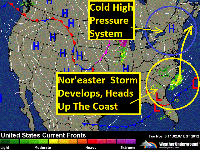
Chilly temperatures are greeting many across the Northeast this election day thanks to a cool high pressure system sitting over the region. Expect high temperatures generally in the 40s for most of the region, with 30s into northern New England. Despite the cold temperatures, this system of high pressure is also producing fair weather for today for the entire region with partly cloudy to mostly sunny skies. For tonight, mostly clear skies will prevail as that high pressure system stays in place, this will allow temperatures to dip into the 20s across much of the region, with 30s along the coast from Boston down to Philly. As we head into Wednesday, fair weather will continue over the Great Lakes, however we'll be monitoring our next weather maker making its way into the picture that will be affecting coastal communities along the Midatlantic and southern New England. A strengthening storm will ride up the eastern seaboard from coastal North Carolina to the Midatlantic on Wednesday. This system is expected to rapidly intensify off the Midatlantic coast from Wednesday evening into early Thursday morning producing heavy precipitation and strong gusty winds for some of the same coastal areas already ravished by Hurricane Sandy one week ago. Winds could gust up and over 50 miles per hour along the immediate coast on Wednesday night from the Jersey Shore to Long Island to Cape Cod. Precipitation will start off as rain Wednesday afternoon initially.
( Rain to start, mixing with snow and sleet overnight Wednesday)
Then depending on the track of this storm as it comes up the coast, there could be enough cold air dragged in on the back side of the storm to produce a mix of rain wet snow and sleet Wednesday night and early Thursday morning with a light accumulation from New Jersey to western Long Island including New York City, up to western Connecticut, western Massachusetts, southern Vermont and New Hampshire, to Maine. A slight change in the storm track would change this forecast considerably. If the storm track closer to the coast precipitation would remain in the form of rain for these areas, with any frozen precipitation pushing further inland. Temperature wise, we can expect the chilly temperatures to stick around for the next few days before a brief warm up heads our way this weekend, with some temperature readings in the 60s returning to the picture on Sunday.
Sunday evening Sandy will begin to turn back to the north, then north
west again about 200 miles east of Cape Hatteras. During this time, as
Sandy turns more westerly towards land it will begin to join forces with
a frontal system that will be moving east toward the coast. From Sunday
evening through Monday, this frontal system will become stationary, and
then begin to literally absorb a vast amount of tropical moisture
associated with Sandy in a virtual tug of war between systems.This will
form a large swath of very heavy rain covering over the Midatlantic and
southern New England.
Because many trees have begun to lose their
leaves, storm drains and sewers will become blocked by these fallen
leaves. This will lead to urban flash flooding especially in those flood
prone areas. As Sandy gets absorbed by this frontal system it will
undergo a metamorphosis, losing its tropical characteristics and
becoming more of a larger hybrid type of storm, something like a super Nor'Easter with tropical storm
forced winds extending out an extraordinary 400 to 500 miles in
diameter with embedded hurricane forced wind gusts.
This hybrid storm is
expected to make landfall somewhere over in the Midatlantic between the
Delmarva Peninsula and the Jersey Shore on Monday with sustained winds
up and over 70 miles per hour. This will have dire repercussions for
coastal communities from: The Chesapeake Bay, to the Jersey Shore, to Long
Island, to Cape Cod as the ingredients for major coastal inundations are
becoming apparent.
These ingredients include: prolonged easterly winds up
to tropical storm force, storm surge associated with Sandy, higher than
normal tides expected during Monday's full moon, as well as heavy rain;
the combination of these factors could potentially, at worst, rearrange
coast lines carving out new inlets and new barrier islands. This storm will also have a wintery
side as cold air gets dragged into the rear flank of the storm. This
could produce a heavy wet snowfall over the higher elevations of the
Appalachians in the Virginas and extreme eastern North Carolina. Wide
spread power outages that will last for several days can be expected for
millions of residents from North Carolina to Long Island due to the
nature of this storm.
This storm could wind up totaling up and over $1
Billion in damages when its all said and done, having both a big economic and human
toll. Like Hurricane Irene last year evacuation orders will likely be
in effect for low lying zones of New York City making this the second
time in history the city has issued evacuation orders due to weather.
This storm will be nothing to sneeze at as tidal flooding could surpass
what was experienced with Irene last year and Hurricane Floyd in 1999.
As of 3:00am Tropical Cyclone Sandy has a minimum central pressure, measured by hurricane reconnaissance, at 968 millibars with maximum sustained winds of 85 miles per hour, gusting to 115 miles per hour making it a category 1 hurricane on the Saffir-Simpson Scale. Sandy is centered approximately 200 miles to the east of Miami, FL currently battering the islands of the Bahamas with hurricane conditions. Its forward movement is to the NNW at 12 miles per hour. Tropical storm forced winds extend approximately 200 miles out from the center of circulation reaching all the way to Florida's east coast. The projected path of Sandy will continue its movement to the NNW until about Friday evening, coming within 100 miles to 150 miles east of Florida. During this time, the east coast of Florida will experience tropical storm forced wind gusts and heavy rain bands associated with Hurricane Sandy to the east. From here, Sandy will begin to turn more to the north, then north east by early Saturday morning. As it does so, its circulation will begin to expand in diameter with bands of heavy rain and tropical storm forced winds reaching eastern North Carolina by Sunday morning. By Sunday evening Sandy will begin to turn back to the north, then north west again about 200 miles east of Cape Hatteras. During this time, as Sandy turns more westerly towards land it will begin to join forces with a frontal system that will be moving east toward the coast. From Sunday evening through Monday, this frontal system will become stationary, and then begin to literally absorb a vast amount of tropical moisture associated with Sandy in a virtual tug of war between systems.This will form a large swath of very heavy rain covering over the Midatlantic and southern New England. Because many trees have begun to lose their leaves, storm drains and sewers will become blocked by these fallen leaves. This will lead to urban flash flooding especially in those flood prone areas. As Sandy gets absorbed by this frontal system it will undergo a metamorphosis, losing its tropical characteristics and becoming more of a larger hybrid type of storm with tropical storm forced winds extending out an extraordinary 400 to 500 miles in diameter with embedded hurricane forced wind gusts. This hybrid storm is expected to make landfall somewhere over in the Midatlantic from the Delmarva Peninsula and the Jersey Shore on Monday with sustained winds up and over 70 miles per hour. This will have dire repercussions for coastal communities from Cape Hatteras to the Jersey Shore, to Long Island, to Cape Cod as the ingredients for major coastal inundations are becoming apparent. These ingredients include: strong easterly winds up to tropical storm force, storm surge associated with Sandy, higher than normal tides expected during Monday's full moon, as well as heavy rain; the combination of these factors could potentially, at worst, rearrange coast lines carving out new inlets. This storm will also have a wintery side as cold air gets dragged into the rear flank of the storm. This could produce a heavy wet snowfall over the higher elevations of the Appalachians in the Virginas and extreme eastern North Carolina. Wide spread power outages that will last for several days can be expected for millions of residents from North Carolina to Long Island due to the nature of this storm. This storm could wind up totaling up and over $1 Billion when its all said and done, having both a big economic and human toll. Like Hurricane Irene last year evacuation orders will likely be in effect for low lying zones of New York City making this the second time in history the city has issued evacuation orders due to weather. This storm will be nothing to sneeze at as tidal flooding could surpass what was experienced with Irene last year and Hurricane Floyd in 1999.
(Satellite Loop of Sandy's Well Defined Eye Crossing Over Cuba)
Tropical Cyclone Sandy is now of Category 2 Hurricane intensity as it moves just to the north of Cuba and into the Bahamas. As of this morning Sandy has a minimum central pressure of 967 millibars and maximum sustained winds of 105 miles per hour gusting to 130 miles per hour around the eye wall, its forward motion is to the north at 18 miles per hour. Sandy crossed the island of Jamaica yesterday evening as a category 1 storm, then overnight its winds increased to 110 miles per hour making it a strong category 2 hurricane over Cuba. This system is forecast to continue on a northerly trajectory this evening and into Friday moving about 150 miles to the east of Florida, as it does so its circulation will expand so even at this distance it will lash southeast Florida with squalls of heavy rain and tropical storm forced wind gusts, mainly confined to the immediate coast from Ft. Lauderdale to Port Canaveral. For this reason, the National Hurricane Center has issued Tropical Storm warnings for southeastern Florida.
(Sandy Sideswipes Florida)
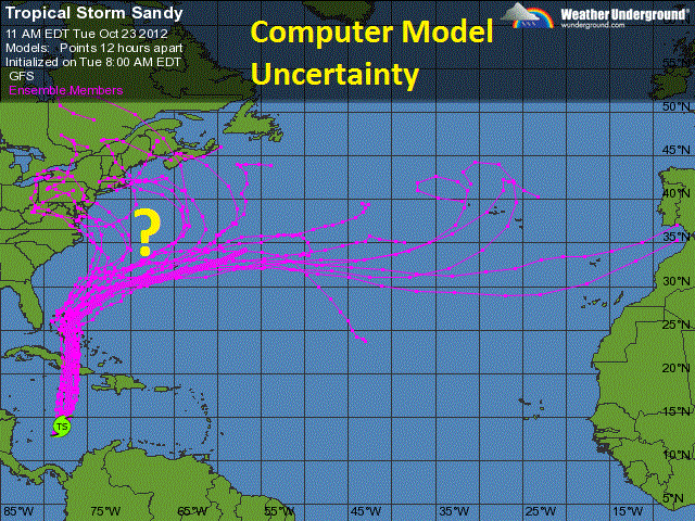
At this point, Sandy's forward speed will begin to increase as it begins to feel the effects of the jet stream. Thereon after predicting the track of this storm begins to get complex as there is a fair amount of disagreement among the forecast models; nevertheless the general consensus for this storm to move northeast and then hook sharply to the west as it phases with a frontal system riding on the jet stream forming one large hybrid storm system or "Subtropical Storm", which exhibits both tropical and extra-tropical characteristics with a wind field extending hundreds of miles. This will produce large swells up and down the eastern seaboard and a tremendous amount of beach erosion. To top it all off, this will come at the astronomical high tide, further amplifying the storm surge anticipated where this system makes landfall. The now question is how soon will this phasing occur, how strong will the storm be and where will it make landfall. Some models suggest a fairly strong storm making landfall between the Delmarva peninsula and southern New Jersey as early as Monday, while others suggest a weaker land falling system over northern New England as late a Wednesday. This broad range in the track will mean the difference between a rainy day with breezy conditions or a powerful Nor'easter like storm with strong gales up to hurricane force, large storm surge and heavy precipitation. It would be wise to monitor this storm's track especially of you live along the coast from Virginia to Long Island, to northern Maine as this situation has the potential to pose a serious economic and human impact.
(Computer Model Uncertain On the Exact Track of the Storm)
For several days now the meteorological community has been monitoring the western Caribbean Sea for the potential of tropical development. Computer models have been consistent with the idea of certain atmospheric parameters that would fall into place in this region that would be conducive for spawning a tropical system.Yesterday a wave of low pressure over the warm waters of the Caribbean within this ripe atmospheric setting has coalesced to form Tropical Storm Sandy, the eighteenth named tropical system of the 2012 Atlantic Hurricane Season. As of the noon time hour, Sandy is centered approximately 300 miles south of the island nation of Jamaica with a minimum central pressure of 993 millibars and maximum sustained winds of 50 miles per hour. Its movement is to the NNE ever so slowly at 4 miles per hour, because Sandy is situated in such a favorable environment, it is expected to intensify to perhaps hurricane status before making its first landfall over Jamaica. Due to its broad circulation and slow forward speed, this system will produce copious amounts of rainfall over Jamaica, Cuba, and the impoverished nation of Haiti. This could have a devastating affect as these are fairly mountainous nations and are prone to mudslides and flash flooding. As Sandy progresses to the north it will likely loose strength as its center of circulation passes over the mountains of Cuba before re-emerging over the waters of the Atlantic Ocean over the Bahamas, likely regaining some strength there. Thereafter, the path of this system will pose a challenge as several factors could influence where Sandy goes next. Some computer models have this system staying away from the US mainland as its influenced by a weak subtropical jet stream and takes it out to sea. While others indicate that Sandy will be influenced by a stronger polar jet stream, if this happens there would be two possible scenarios depending on the timing of the jet streams' interaction with Sandy. In the first case scenario, Sandy would begin to interact with the jet stream sooner, this would bring its circulation on a close approach to the east coast of Florida by Friday bringing bands of heavy rain and perhaps tropical forced winds to places like West Palm Beach before it re-curves out to the open waters of the Atlantic. In the second and perhaps worst case scenario, Sandy would begin to interact with the jet stream later moving north past the Bahamas and then accelerate on a bee line up the eastern seaboard targeting anywhere from North Carolina to Maine this weekend. In this worst case scenario, Sandy would be absorbed by a storm system with an associated cold front that will be ridding on the jet stream that will be moving east from the Great Lakes. The phasing of these two system has the potential to wreak havoc on the eastern US from the Midatlantic to New England as well as locations inland from the coast in the Northeast as some models suggest. It is important to note that nothing is set in stone, there is little confidence in the forecast at this time to predict what influence, if any, this system will have on the forecast but it does bear watching.
(Computer Model Uncertainty)
Just for fun, lets discuss some of the bizarre details that some computer models are predicting this weekend; continuing on the absolute "worst case scenario" as Sandy begins to interact with this other storm system riding on the jet stream, the two storms will phase with one another just off the east coast of the Midatlantic. A swath of heavy precipitation will break out over the Northeast with gale and storm forced winds from Virginia to New England producing tremendous beach erosion and coastal flooding. Once Sandy becomes completely absorbed by the frontal boundary the entire system will become "negatively tilted" pulling an incredible amount of tropical moisture out ahead of it over New England producing torrential rains and flash flooding; while dragging cold air in on the back side producing a swath of heavy wet snow with thunder and lightning over interior sections of the Northeast and Midatlantic especially over the higher elevations of the Appalachians leading to wide spread powers outages for days. The entire system will then lift north into Canada early next week losing strength as it does so. This would be an historic storm if it pans out this way; as bizarre and highly unlikely as it seems, this has happened before during the super storm dubbed "The Perfect Storm" this time back in 1991 when Hurricane Grace phased with a frontal system ridding on the jet stream just off the east coast causing devastation in the Northeast.
(1991 Satellite Imagery Hurricane Grace Pahses with a Frontal System off the Northeast Coast)
This article is attributed to AccuWeather.com, a great
source for weather news, and forecast.
(Negative phase of the Arctic Oscillation (higher pressures over the Arctic), which forces cold air farther south into the mid-latitudes)
Higher pressure over the North American continent and
Greenland are driving recent changes in the wind patterns across the Arctic,
which are impacting sea ice and could bring changes to the weather across North
America and Europe, according to a new study that was led by NOAA.
Researchers examined the wind patterns in the subarctic in
the early summer between 2007 and 2012 as compared to the average for 1981 to
2010. They discovered that the previously normal west-to-east flowing
upper-level winds have been replaced by a more north-south undulating, or
wave-like pattern, according to the NOAA news report.
This new wind pattern transports warmer air into the Arctic and pushes Arctic air farther south towards the mid-latitudes, potentially leading to more persistent weather patterns.
Enhanced warming of the Arctic affects the jet stream by slowing its west-to-east winds and by promoting larger north-south meanders in the flow, according to NOAA.
However, predicting those meanders and where the weather associated with them will be located in any given year, however, remains a challenge, according to NOAA.
For example, the previous two winters were very different from one another in North America. There was strong high pressure blocking in the northern latitudes both winters, but the position of these high pressure ridges was very different. Knowing where these blocking highs set up during long periods of the winter is crucial to the forecasts.
The researchers say that with more solar energy going into the Arctic Ocean because of lost ice, there is reason to expect more extreme weather events, such as heavy snowfall, heat waves, and flooding in North America and Europe but these will vary in location, intensity, and timescales. (from NOAA)
As the Arctic warms at twice the global rate, we expect an increased probability of extreme weather events across the temperate latitudes of the northern hemisphere, where billions of people live," said Jennifer Francis, Ph.D, of Rutgers. (from NOAA)
----------
The study, entitled "The Recent Shift in Early Summer Arctic Atmospheric Circulation," was co-authored by scientists from Rutgers University in New Jersey, the University of Sheffield in the United Kingdom, and the Joint Institute for the Study of the Atmosphere and Ocean, a partnership of NOAA and the University of Washington.
As of Tuesday morning Tropical Cyclone Rafael is a category 1 Hurricane over the western Atlantic with maximum sustained winds of 90 miles per hour gusting to 115 miles per hour, and a minimum central pressure of 971 millibars. Its movement is to the NNE at 24 miles per hour away from the US and is accelerating as it is essentially picked up by the jet stream. Its current trajectory will bring the center of Rafael on a close approach to Bermuda by this evening bringing torrential rains and tropical storm force winds to the island. But just as quickly at it comes in it will go out as its forward speed increases with the influence of the strong October jet stream. By this time tomorrow, Rafael will begin to lose its tropical characteristics becoming extra tropical over the cooler waters of the northern Atlantic Ocean where it will remain of maritime interest. Looking ahead, there are indicators of a region of favorable tropical storm development setting up over the western Caribbean as the month of October comes to a close. Some models indicate a region of reduced wind shear aloft over this region and at the same time, a wave of low pressure moving in from central America. With water temperatures in the Caribbean well into the 80s, it is plausible to perceive the notion that if these atmospheric conditions do indeed transpire there could very well be tropical development in this region. Some forecast models have been consistent with the idea of some tropical system developing over the this region by mid next week that could potentially threaten the US mainland, particularly the state of Florida. At this point, forecast confidence is low. Even though it is much too soon to call, this does bear watching.
An area of unorganized thunderstorms in the vicinity of the Bahamas associated with a stalled out frontal boundary that has persisted over the past week has coalesced to form a closed circulation at surface levels. The National Hurricane Center in Miami, FL has dubbed this system Tropical Storm Patty, the 16th named tropical system of the 2012 Atlantic Hurricane Season. As of 12:00 am Friday morning, Patty is centered just north of the Bahamas; it is a fairly weak storm with a minimum central pressure of 1005 millibars and maximum sustained winds of 45 miles per hour. This system is not expected to further develop, as a strong jet stream will hinder any further strengthening. Tropical Storm Patty is expected to slowly track to the west south west while loosing its convection and becoming an open circulation over the Bahamas, while its thunderstorms gets sheared away by the jet stream. This system will have minor impacts if any for the US, including an elevated risk of rip currents and enhanced thunderstorm activity over southern Florida early next week but that's about it. Statistically, the month of October does produce a shorter secondary peak in tropical storm activity over the Atlantic Ocean, so it is not uncommon to see the tropics ramp up after a lull in activity after the real peak in mid September, however these storms tend to encounter strong wind shear aloft as the jet stream becomes more amplified towards the fall and winter months. Looking ahead, there are indications of another tropical system developing this weekend. A tropical wave to the east of the lesser Antilles will move north into a more favorable region with reduced shear. If it does develop it will be named Rafael, this potential storm system does have the opportunity to become a stronger and more organized storm early next week but will pose no threat to the US. It is expected to be absorbed by the jet stream, loosing its tropical characteristics threatening the island of Bermuda on its northerly track.
Fall is in the air over the Northeast on this cool October morning as temperatures dipped into the 30s and 40s from the lower Great Lakes to the Mid Atlantic and New England. A High pressure system over the region is to blame for the chilly temperatures experienced forcing many to crank up the thermostats last night. This area of High Pressure will stick around today providing cool and dry sinking air, promoting mostly sunny conditions across the region. Our next weather maker will arrive on Friday as a cold front will once again sweep the region giving us a reinforcing shot of cold air, producing a wide spread frost for most of the region during the overnight hours on Friday into Saturday. High temperatures on Friday will be stuck in the 40s across interior sections of the Northeast with 50s closer to the Atlantic coast, overnight Lows will be dipping into the 20s and 30s. Along with the cold air, there is a chance of light precipitation during the morning hours across the lower Great Lakes on Friday, though it will feel as if its cold enough for snow, precipitation will likely be a light drizzle or rain shower ending well before Noon. Aside from the cold, Friday will turn out to be a pleasent day weather wise as another area of High Pressure trails in the wake of the cold front. What about the weekend? we can look forward to a nice warm up across the region as the High Pressure system moves off to our east and a southerly flow sets up behind it ushering in a moderating airmass; however we can expect rain and some thunderstorms late Saturday night into Sunday confined to western and central New York State as a storm system approaches from the west. Looking into next week the forecast calls for warmer tempratures with the possibility of rain for both the begining and the end of the work week, with the greatest chance of precipitation likely at the end of the work week. This weekened would be a great time to head out and experience the brilliant colors of Autumn for us fall enthusiast. Weather conditions have been ripe for nature's aray of colors; the combination of the recent dry spell this summer along with the waves of cold air these past few weeks are making for a spectcular display of fall foliage across the region with many locations approaching peak conditions.
Welcome to October; for many it is the best time of the year as temperatures begin to fall, leaves begin to change, and the MLB playoffs gets into high gear. Weather wise, the month is off to a rainy start in the Northeast as a storm system centered over the Tennessee valley is producing unsettled conditions over the region. The chance of precipitation will remain through Wednesday in the Mid Atlantinc and into Thursday for New England as this area of low pressure lifts north into Canadian terretories. Along with the rain, this system will moderate our temperatures a bit across the Northeast, highs in the upper 60s and 70s can be expected for the remainder of the work week before big changes head our way this weekend. The month of October is known for highly changable weather and big temperature swings over the northern U.S. as we are heading well into the fall season. This week will be no exception, there are already signs of this flux in the forecast as a cold front is piercing through the Nothern Rockies today. This cold front marks the leading edge of colder temperatures and is forcast to invade the Northern Plains Wednesday and Thursday producing the first few inches of snow fall of the season for many folks in the path of this cold air intrusion from Montana, the Dakotas and northern Minesota. This cold airmass will be moderating as it pushes east, but will still remain quite chilly as it approaches the Northeastern U.S. this weekend and early next week, initiating the first frost for much of the interior sections of the region with overnight lows dipping into the 30s and afternoon highs hard pressed to rise above the 50s. Along with the dip in temperatures, this cold front will bring a chilly rain on Saturday from central Pennsylvania through Western New York and Sunday from the Mid Atlantinc on north to New England.
This article is attributed to AccuWeather.com, a great source for weather news, and forecast.
Like the National Football League referee situation, the National Oceanic and Atmospheric Administration (NOAA) is using a replacement satellite to cover the failure of GOES-13. A major weather satellite operated by the U.S. government to monitor the east coast of the U.S. and the Atlantic Ocean has gone dark due to technical issues. The failure of Satellite GOES-13 (GOES-East) satellite has left a gap for meteorologists trying to catch a view of the eastern Atlantic and has satellite coverage of the Atlantic spread a bit thin.
GOES-14 was activated and repositioned on Monday to fill part of the void left to satellite imagery in eastern North America and the Atlantic. However, images on the eastern edge of view, over the eastern Atlantic are distorted. While other satellites of the eastern Atlantic are available, such as the European operated, METEOSAT, it makes the tracking of systems within the entire basin as a whole more difficult. The U.S also has polar orbiting satellites. However, the images are rather narrow and not continuous, like the GOES, geostationary satellites.
The National Oceanic and Atmospheric Administration (NOAA) confirmed Monday that GOES-13 has been placed in stand-by mode, following increased vibrations, or "noise," observed in imagery over the past couple of days. Launched in 2006, GOES-13 went operational in 2010 and was expected to remain in service for several more years. Stand-by mode means the satellite has basically been taken offline until problems are resolved.
The vibrations were severe enough that data collection and imagery was returning to earth significantly degraded over the past couple of days. NOAA engineers are currently working on a solution to correct the problem with GOES-13 from the ground and have no timetable for return of data collection. Earlier this year, in March, GOES-15 (GOES-West) was out of action for several days and it was GOES-13 that had to be repositioned to fill part of the gap. The result was distorted images on part of the Pacific Basin for a time. Launch of the first of a new generation of weather satellites, known as the GOES-R series is not scheduled to begin until 2015.
Satellite images and loops are is available for free at AccuWeather.com
As of Sunday morning, Tropical Cyclone Isaac is currently at tropical storm intensity with maximum sustained wind speeds up to 65 miles per hour, only 9 miles per hour shy of hurricane intensity. Tropical storm forced winds of 39 miles per hour or greater associated with Isaac extend as far out as West Palm Beach, Florida. The center of circulation is just to the south east of the Florida Keyes. The strongest winds associated with Isaac will be felt in the most intense rain bands in the upper right hand quadrant of the storm. There is an elevated risk of flooding as well as tornadoes for all of south Florida as it is not uncommon for land-falling tropical systems to produce torrential rains and rain wrapped tornadoes. Unfortunately, conditions will get worst through the evening on Sunday before they begin to improve on Monday across southern Florida. Upper level winds are expected to steer Isaac into the open waters of the northern Gulf of Mexico, an area that is favorable for strengthening. Isaac is expected to rapidly intensify to category 2 hurricane status with winds up and over 100 miles per hour. Isaac is expected to make a secondary land-fall some where along the northern coast of the Gulf of Mexico, although there is uncertainty as to where the center of circulation will make land-fall the impacts will be wide spread as it is a fairly large circulation. Residents along the Gulf of Mexico from the Florida panhandle to Louisiana need to keep a close eye on this storm as this storm will pose a serious threat to life and property.
TEMPERATURES ON SATURDAY WILL CLIMB INTO THE MID 90S...AND WHEN
COMBINED WITH A MODERATELY HUMID AIRMASS...THIS WILL POTENTIALLY
RESULT IN DANGEROUSLY HIGH HEAT INDICES THAT WILL BE IN THE
VICINITY OF 100 DEGREES. HEAT INDEX VALUES OF THIS MAGNITUDE
WOULD PROMPT A HEAT ADVISORY.
LATER IN THE WEEKEND...THERE WILL BE THE THREAT OF SEVERE WEATHER.
THUNDERSTORMS WILL BE LIKELY SUNDAY AND SUNDAY NIGHT AS A COLD
FRONT WILL CROSS OUR REGION. SOME OF THESE STORMS COULD BECOME
SEVERE.
The National Oceanic and Atmospheric Administration, The Weather Channel, The Weather Underground, AccuWeather, WKBW Meteorologist Mr. Aaron Mentkowski, Buffalo State Meteorology Professor Dr. Stephen Vermette.