Sunday, August 26, 2012
Tracking Tropical Cyclone Isaac (8/26)
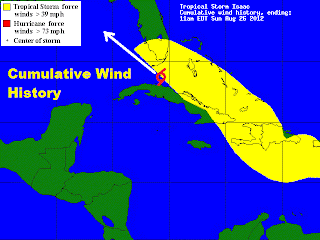
As of Sunday morning, Tropical Cyclone Isaac is currently at tropical storm intensity with maximum sustained wind speeds up to 65 miles per hour, only 9 miles per hour shy of hurricane intensity. Tropical storm forced winds of 39 miles per hour or greater associated with Isaac extend as far out as West Palm Beach, Florida. The center of circulation is just to the south east of the Florida Keyes. The strongest winds associated with Isaac will be felt in the most intense rain bands in the upper right hand quadrant of the storm. There is an elevated risk of flooding as well as tornadoes for all of south Florida as it is not uncommon for land-falling tropical systems to produce torrential rains and rain wrapped tornadoes. Unfortunately, conditions will get worst through the evening on Sunday before they begin to improve on Monday across southern Florida. Upper level winds are expected to steer Isaac into the open waters of the northern Gulf of Mexico, an area that is favorable for strengthening. Isaac is expected to rapidly intensify to category 2 hurricane status with winds up and over 100 miles per hour. Isaac is expected to make a secondary land-fall some where along the northern coast of the Gulf of Mexico, although there is uncertainty as to where the center of circulation will make land-fall the impacts will be wide spread as it is a fairly large circulation. Residents along the Gulf of Mexico from the Florida panhandle to Louisiana need to keep a close eye on this storm as this storm will pose a serious threat to life and property.
Subscribe to:
Post Comments (Atom)


No comments:
Post a Comment