Already one week into the start of the 2013 Atlantic hurricane season, which began on June 1st, we have our first named tropical cyclone. As of 11:00 AM Tropical Storm Andrea is centered 160 miles to the east of Tampa moving to northeast at 14 miles per hour with maximum sustained wind speeds of 60 miles per hour gusting up to 70 miles per hour and a minimum central pressure of 997 millibars. Andrea is expected to continue producing heavy rain for the state of Florida along with the threat of isolated tornadoes embedded with in the heavier rain bands.
 |
| (Click Image to Expand) Tropical Cyclone Andrea Impacts Florida |
The center of circulation is expected to make landfall to the east of
Tallahassee this evening after 5:00 PM eastern time. From there, the
storm will weaken loosing its tropical characteristics as it accelerates in forward speed tracking up the east coast producing heavy rain from Georgia to Maine. Heavy rain from what remains of Andrea will impact the New York City metropolitan area on Friday, ending by the early morning hours of Saturday.
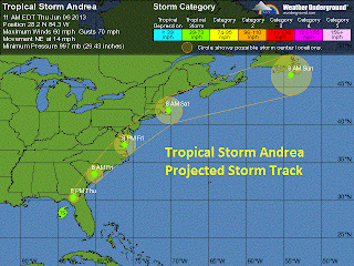 |
| (Click Image to Expand) Tropical Cyclone Andrea Projected Storm Track | | |
|


No comments:
Post a Comment