 |
| (Click Image to Enlarge) Courtesy of Accuweather |
Wednesday, June 26, 2013
Weather Synopsis: Wednesday June 26, 2013
The heat across the Northeast continues today as we brace for yet another 90+ degree day here in the New York City Metropolitan area. Along with the heat the humid air mass in place over the region will also give us the chance for pop-up thunderstorms in the evening.
The storms will become more wide spread I think overnight tonight, through the day on Thursday and on into Friday as a low pressure system moves into the region from the Ohio river valley. This system of low pressure will make the atmosphere more unstable, this will increase the chance of precipitation in our area through Friday. On the plus side, the increased cloud cover will keep the temperatures at bay in the 80 degree range, however it will still feel rather muggy as this humid air mass continues its grasp over the region. What about the weekend? well its looking muggy and wet, though not a complete washout there is a chance of rain with the greatest chance of precipitation on Sunday.
Tuesday, June 25, 2013
Monday, June 24, 2013
Weather Synopsis: Monday June 24, 2013
The first full week of summer is upon us and right on cue mother nature is responding by turning up the heat. The National Weather Service has issued a Heat Advisory for all of New York City which is in effect through Tuesday. Temperatures today and tomorrow are expected to top off in the lower to middle 90s; when you factor in the humidity, heat indexes will feel more like the upper 90s to 100 degrees. The question, whats causing all this heat? The answer, a high pressure system off the eastern seaboard over Bermuda; the clockwise flow around this system of high pressure is spewing in a sticky hot and humid air mass from the south.
This air mass looks like it will be hanging around at least through the rest of the week as this Bermuda High will continue to pump hot and humid air up into the northeast. This heat and humidity will foster an environment favorable for the typical garden variety late day pop up thunderstorms giving us a chance of storms in the evening through the week.
 |
| (Click Image to Expand) Courtesy of Accuweather |
Thursday, June 6, 2013
Hurricane Season 2013: Tropical Cyclone Andrea
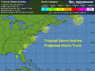
Already one week into the start of the 2013 Atlantic hurricane season, which began on June 1st, we have our first named tropical cyclone. As of 11:00 AM Tropical Storm Andrea is centered 160 miles to the east of Tampa moving to northeast at 14 miles per hour with maximum sustained wind speeds of 60 miles per hour gusting up to 70 miles per hour and a minimum central pressure of 997 millibars. Andrea is expected to continue producing heavy rain for the state of Florida along with the threat of isolated tornadoes embedded with in the heavier rain bands.
The center of circulation is expected to make landfall to the east of
Tallahassee this evening after 5:00 PM eastern time. From there, the
storm will weaken loosing its tropical characteristics as it accelerates in forward speed tracking up the east coast producing heavy rain from Georgia to Maine. Heavy rain from what remains of Andrea will impact the New York City metropolitan area on Friday, ending by the early morning hours of Saturday.
 |
| (Click Image to Expand) Tropical Cyclone Andrea Impacts Florida |
 | |||
| (Click Image to Expand) Tropical Cyclone Andrea Projected Storm Track |
Subscribe to:
Posts (Atom)


