(Click Image to Expand)
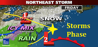
A slew of winter weather advisories are in effect for the entire Northeastern United States from Friday into Saturday. Two storm systems are forecast to phase just off the southern shore of Long Island on Friday and morph into a larger, strengthening coastal storm that will bring the threat for significant snowfall, strong winds, and coastal flooding especially along the Atlantic coast from Long Island to the Gulf of Maine.
(Click Image to Expand)
The first storm will begin to affect the western parts of the region on Friday morning as an Alberta clipper that is ridding on the polar jet stream moves east, slows down and begin to intensify. This will produce a period of heavy snow for the Great Lakes region from Buffalo to the Tug hill Plateau where 6" to as much as 12" of snow accumulations are possible by Saturday morning. This system is expected to interact and phase with a secondary storm system that is ridding on the sub-tropical jet stream some time during Friday evening just off the coast of the southern shores of Long Island. The exact timing of the phasing as well as the proximity of this storm to the coast will determine where the rain/snow line sets up which will govern the precipitation type in the New York City metropolitan area. Here precipitation will likely mix with and change over to all rain for a time before changing over to snow late Friday night and into early Saturday morning. The potential exists for 4" to as much as 8" of snow accumulation or greater for the New York City metropolitan area with the highest amounts east towards eastern Long Island. However if precipitation were to remain in the form of snow through out the event we could be dealing with snow accumulations ranging between over 12" in New York City to as much as 20" east towards eastern Long Island.
(Click Image to Expand)
The big winner, or looser in terms of snow accumulations and storm impacts with this system will be southern New England including Providence, RI, Boston, MA and coastal Maine where as much as 20" and up to 30" of snowfall is expected along with strong gusty winds that will produce an all out Blizzard from late Friday into early Saturday. Snowfall rates in southern New England during the height of the storm are projected to be between 2" to 4" per hour! These kinds of snowfall intensities will halt all transportation, if you are driving in these conditions you WILL become stranded! Now is the time to prepare for this event, this storm will have MAJOR impacts on travel; you might want to reconsider any travel arrangements if you're planning on venturing out on the roads as conditions could become life threatening in these areas especially along the I-95 corridor from New York City to coastal Maine.


No comments:
Post a Comment