U.S. National Radar

Comet Ison Viewing Guide

Thursday, November 29, 2012

Peak Winds Measured In The New York Metropolitan Area During Sandy

Tropical Storm Force Winds: 39-73 Miles Per Hour

Hurricane Force Winds: 74 Miles Per Hour or Greater

(Click Image To Expand)

Monday, November 19, 2012

Weather Synopsis November 19th 2012

(Pleasant Conditions Continue This Week)
 
After a calm and fair stretch of weather last week, our streak of pleasant conditions will persist through our Thanksgiving week. Expect dry conditions to prevail across the Northeast as we go through one of the busiest travel weeks of the year. In addition to the fair weather, afternoon high temperatures will moderate as we approach the Thanksgiving holiday. Highs this week will range in the 50s and even approach 60 degrees on Thanksgiving day and on Black Friday. However, it is late November in the Northeast and these pleasant and unseasonably mild conditions wont last much longer. Our next weather maker will begin to impact western portions of the region beginning late Friday; a cold front  will approach the lower Great Lakes Friday night initiating some light rain showers. This frontal system will sweep though the entire region through the day Saturday ushering in a much colder and more seasonable air mass. Behind the front the first Lake Effect snow showers of the season are likely on Saturday downwind of the lakes. Buffalo could pick up its first measurable snow flurries of the season with a few inches of the white stuff not out of the question. Moreover, this cold front will mark the beginning of a change in the weather pattern.

(Changing Weather Pattern After Thanksgiving)
 
The long range forecast after this week suggest we will be going from a zonal jet stream which  promoted the fair weather over the past week, to a more amplified meridional flow which, this time of the year favors a colder, more active, stormier and snowier weather pattern. This is the same weather pattern that brought us prolonged cold conditions as well as the memorable blizzards during the 2010-2011winter season two years ago. We lucked out with mild conditions last winter, but if this forecast holds true we could be in line for a harsh winter season. In summary, expect another week of fair weather before we begin to see the signs old man winter rearing his ugly head in the weeks to come.

Tuesday, November 13, 2012

Weather Synopsis November 13th 2012

(No storms expected this week)

The spring like weather that greeted the region from Sunday through the better half of Monday has been replaced with more seasonal conditions thanks to a cold front which swept through the region yesterday evening, replacing the mild 70 degrees we experienced with colder 30's. In addition to the cold temperatures  the cold front also produced rain as it traveled eastward with some light Lake Effect Snow showers downwind of the Lakes. The rain continues this morning along the Atlantic coast as the cold front is finally making its way out of the picture, as it does so expect conditions to improve through the course of the day. In the wake of this cold front, high pressure will dominate our weather as we head through the rest of the week. This high pressure system will promote a nice stretch of fair, but chilly weather over the Northeast through the end of the week. High temperatures this week will generally range in the low to mid 40's with upper 40's to low 50's along the coast, while overnight lows dip into the low 30's, with upper 30's along the coast. To sum it all up, the good news is that there are no storm on the horizon; this means that there is a much needed  dose of fair weather for residents of the New Jersey, New York City and Long Island area who are still rebuilding after Hurricane Sandy, after last week's Nor'easter put a damper on the clean up efforts.

Thursday, November 8, 2012

November 7th Nor'easter Snowfall Totals in the Tristate Area

Snow Accumulations in New York

Westchester: 9.5" (Bronxville)
                       6.3" (Yonkers)
                       5.0" (White Plains)

Manhattan: 4.7" (Central Park)

Bronx: 5.0" (Parkchester)
             4.4" (Riverdale)
             3.0" (City Island)

Brooklyn: 4.0" (Marine Park)
                  4.0" (Bay Ridge)
                  3.5" (Sheepshead Bay)

Queens: 7.9" (Bayside)
               7.0" (Flushing)
               4.2" (Astoria)

Staten Island: 6.4" (Great Kills)
                        3.0" (Fort Wadsworth)

Suffolk: 5.8" (Stony Brook)
              5.0" (Ronkonkoma)
              4.0" (Macarthur Airport)

Nassau: 8.0" (Valley Stream)
               7.0" (Rockville Center)
               4.1" (Wantagh)

Snow Accumulations in New Jersey

Bergen: 7.5" (Ridgefield)
               4.0" (Paramus)

Essex: 6.2" (Newark Airport)
             6.0" (Caldwell)

Hudson: 6.0" (Jersey City)
                3.3" (Hoboken)

Union: 5.4" (Elizabeth)
             3.5" (Union)

Snow Accumulations in Connecticut

Fairfield: 13.5" (Monroe)
                  8.0" (Bridgeport)
                  5.3" (Stamford)

New Haven: 9.0" (New Haven)
                      6.3" (Waterbury)

Tuesday, November 6, 2012

Weather Synopsis November 6, 2012

(Cold air in place ahead of a coastal storm)
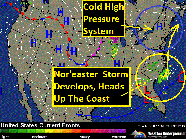
Chilly temperatures are greeting many across the Northeast this election day thanks to a cool high pressure system sitting over the region. Expect high temperatures generally in the 40s for most of the region, with 30s into northern New England. Despite the cold temperatures, this system of high pressure is also producing fair weather for today for the entire region with partly cloudy to mostly sunny skies. For tonight, mostly clear skies will prevail as that  high pressure system stays in place, this will allow temperatures to dip into the 20s across much of the region, with 30s along the coast from Boston down to Philly. As we head into Wednesday, fair weather will continue over the Great Lakes, however we'll be monitoring our next weather maker making its way into the picture that will be affecting coastal communities along the Midatlantic and southern New England. A strengthening storm will ride up the eastern seaboard from coastal North Carolina to the Midatlantic on Wednesday. This system is expected to rapidly intensify off the Midatlantic coast from Wednesday evening into early Thursday morning producing heavy precipitation and strong gusty winds for some of the same coastal areas already ravished by Hurricane Sandy one week ago. Winds could gust up and over 50 miles per hour along the immediate coast on Wednesday night from the Jersey Shore to Long Island to Cape Cod. Precipitation will start off as rain Wednesday afternoon initially.

( Rain to start, mixing with snow and sleet overnight Wednesday)
Then depending on the track of this storm as it comes up the coast, there could be enough cold air dragged in on the back side of the storm to produce a  mix of rain wet snow and sleet Wednesday night and early Thursday morning with a light accumulation from New Jersey to western Long Island including New York City, up to western Connecticut, western Massachusetts, southern Vermont and New Hampshire, to Maine. A slight change in the storm track would change this forecast considerably. If the storm track closer to the coast precipitation would remain in the form of rain for these areas, with any frozen precipitation pushing further inland. Temperature wise, we can expect the chilly temperatures to stick around for the next few days before a brief warm up heads our way this weekend, with some temperature readings in the 60s returning to the picture on Sunday.