
 |
| (Click Image to Enlarge) Courtesy of Accuweather |
Wednesday, June 26, 2013
Weather Synopsis: Wednesday June 26, 2013
The heat across the Northeast continues today as we brace for yet another 90+ degree day here in the New York City Metropolitan area. Along with the heat the humid air mass in place over the region will also give us the chance for pop-up thunderstorms in the evening.
The storms will become more wide spread I think overnight tonight, through the day on Thursday and on into Friday as a low pressure system moves into the region from the Ohio river valley. This system of low pressure will make the atmosphere more unstable, this will increase the chance of precipitation in our area through Friday. On the plus side, the increased cloud cover will keep the temperatures at bay in the 80 degree range, however it will still feel rather muggy as this humid air mass continues its grasp over the region. What about the weekend? well its looking muggy and wet, though not a complete washout there is a chance of rain with the greatest chance of precipitation on Sunday.


Tuesday, June 25, 2013
Monday, June 24, 2013
Weather Synopsis: Monday June 24, 2013
The first full week of summer is upon us and right on cue mother nature is responding by turning up the heat. The National Weather Service has issued a Heat Advisory for all of New York City which is in effect through Tuesday. Temperatures today and tomorrow are expected to top off in the lower to middle 90s; when you factor in the humidity, heat indexes will feel more like the upper 90s to 100 degrees. The question, whats causing all this heat? The answer, a high pressure system off the eastern seaboard over Bermuda; the clockwise flow around this system of high pressure is spewing in a sticky hot and humid air mass from the south.
This air mass looks like it will be hanging around at least through the rest of the week as this Bermuda High will continue to pump hot and humid air up into the northeast. This heat and humidity will foster an environment favorable for the typical garden variety late day pop up thunderstorms giving us a chance of storms in the evening through the week.
 |
| (Click Image to Expand) Courtesy of Accuweather |
Thursday, June 6, 2013
Hurricane Season 2013: Tropical Cyclone Andrea
Already one week into the start of the 2013 Atlantic hurricane season, which began on June 1st, we have our first named tropical cyclone. As of 11:00 AM Tropical Storm Andrea is centered 160 miles to the east of Tampa moving to northeast at 14 miles per hour with maximum sustained wind speeds of 60 miles per hour gusting up to 70 miles per hour and a minimum central pressure of 997 millibars. Andrea is expected to continue producing heavy rain for the state of Florida along with the threat of isolated tornadoes embedded with in the heavier rain bands.
The center of circulation is expected to make landfall to the east of
Tallahassee this evening after 5:00 PM eastern time. From there, the
storm will weaken loosing its tropical characteristics as it accelerates in forward speed tracking up the east coast producing heavy rain from Georgia to Maine. Heavy rain from what remains of Andrea will impact the New York City metropolitan area on Friday, ending by the early morning hours of Saturday.
 |
| (Click Image to Expand) Tropical Cyclone Andrea Impacts Florida |
 | |||
| (Click Image to Expand) Tropical Cyclone Andrea Projected Storm Track |
Thursday, April 4, 2013
Thursday, March 21, 2013
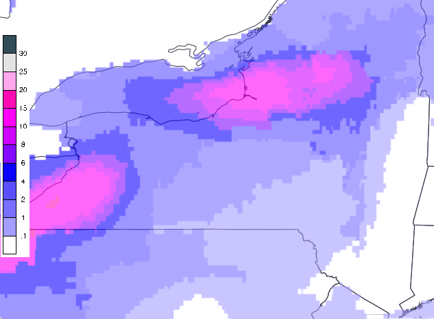
Wednesday, March 13, 2013

Thursday, March 7, 2013
Tuesday, March 5, 2013

Monday, March 4, 2013
Potential Nor'Easter for the NYC Metro Area this week 3/6 to 3/7
The National Weather Service in Upton, NY has posted a Winter Storm Outlook for the New York City Metropolitan area for the possibility of a coastal storm that could impact the region this week around Wednesday evening into the early hours of Thursday morning. A storm system currently impacting portions of the upper Midwest is expected to move east towards the Midatlantic this week producing significant snows for a wide area along its path. This storm is forecast to strengthen off the south Jersey and Delmarva coast and produce a period of heavy rain that will be transitioning to a heavy wet snow along the Midatlantic including the Baltimore Washington and northern Virginia area on Wednesday. From this point, the track in which this storm takes will determine what impacts, if any, it will have on the New York City Metro area. If this system continues due east, impacts from this storm will be focused well south of NYC Metro. However, if this system takes more of a northeasterly track, there is the potential for significant snow accumulations as well as strong gusty winds and moderate coastal flooding for northern New Jersey, New York City, Long Island and extreme southern New England. At this time, forecast confidence for a big snow event over the NYC Metro is low, but any changes in the projected storm track can significantly change the forecast. Stay tuned!
Tuesday, February 19, 2013
10 Year Anniversary of the Presidents Day II Storm of 2003
 |
| This was one of the big weather events that stirred my interest in Meteorology. |
Thursday, February 14, 2013
Potential Nor'Easter Developing This Weekend

(Click Image to Expand)
A coastal low will be developing on Friday night and will track southeast of Long Island by Saturday night. At the moment there is a low probability that this low could bring significant snowfall from New York City to eastern Long Island, there is a better chance that this low will track far enough off shore that it will bring little to no impacts to the region.

(Click Image to Expand)
The exact track as well as its timing of this storm will determine what impacts if any could be expected for the tristate area. Either way, some very cold air will be ushered in behind this system that will stick around for the duration of the weekend across the entire Northeastern US.
Wednesday, February 13, 2013
Winter Weather Advisory For Eastern Long Island in Effect Tonight
THE NATIONAL WEATHER SERVICE IN UPTON HAS ISSUED A WINTER WEATHER
ADVISORY FOR SNOW...WHICH IS IN EFFECT FROM 5 PM THIS AFTERNOON TO 6
AM EST THURSDAY.

(Click Image to Expand)* LOCATIONS...SOUTHERN NASSAU AND SUFFOLK COUNTIES ON LONG ISLAND. * HAZARD TYPES...SNOW. * ACCUMULATIONS...SNOW ACCUMULATION OF 2 TO 5 INCHES...HIGHEST ACROSS EASTERN LONG ISLAND. THERE IS A LOW PROBABILITY FOR 4 TO 8 INCHES...ONLY IF HEAVY SNOW BANDING WORKS NORTH INTO THE AREA.

(Click Image to Expand)
* WINDS...NORTHEAST 10 TO 15 MPH WITH GUSTS UP TO 25 MPH.

* TEMPERATURES...IN THE LOWER 30S.

* VISIBILITIES...ONE HALF MILE AT TIMES. THERE IS A LOW
  PROBABILITY FOR ONE QUARTER MILE OR LESS AT TIMES...ONLY IF
  HEAVY SNOW BANDING WORKS NORTH INTO THE AREA.

* TIMING...THIS EVENING INTO TONIGHT.

* IMPACTS...HAZARDOUS TRAVEL CONDITIONS DUE TO REDUCED
  VISIBILITIES AND SNOW COVERED ROADS. THE WORST CONDITIONS ARE
  EXPECTED AFTER THIS EVENING RUSH INTO THE OVERNIGHT. ALTHOUGH
  SNOW IS EXPECTED TO END BY THE THURSDAY MORNING RUSH...ROADS
  WILL STILL BE SNOW COVERED.
Monday, February 11, 2013
Asteroid 2012 DA14 Fly-by on February 15th
Asteroid 2012 DA14 discovered in 2012 by a group of Spanish astronomers is expected to make a close approach to Earth on Friday February 15th 2013. So close in fact that it will pass between the Earth and our Geostationary satellite orbits. The asteroid, on its closest approach, will pass with in 18,000 miles of the Earth's surface making it the closet approach ever observed by NASA since they began monitoring near Earth objects in 1990. The asteroid is approximately half the size of a football field and will be visible with a telescope from eastern Europe, southeast Asia, and Australia. However due to its speed it will be difficult to detect by armature star gazers.
New England Blizzard Snowfall Totals and Peak Gusts
Below is a graphical depiction of the Snowfall Totals after the blizzard:

(Click Image Expand)
Connecticut:
Hamden - 40.0 inches
Milford - 38.0 inches
Clintonville - 37.0 inches
Oxford - 36.2 inches
East Haddam - 35.5 inches
Yalesville - 35.0 inches
New Haven - 34.3 inches
Gilford - 33.0 inches
Manchester - 32.0 inches
Maine:
Gorham - 35.5 inches
Berwick - 32.0 inches
Portland - 31.9 inches (All-Time Greatest Snowstorm)
Westbrook - 30.0 inches
Augusta - 28.0 inches
Lewiston - 25.5 inches
Massachusetts:
Framingham - 32.2 inches
Spencer - 31.0 inches
Northboro - 29.5 inches
Foxboro - 29.0 inches
Worcester - 28.7 inches (3rd Highest Storm Total)
Southwick - 28.3 inches
Saugus - 28.2 inches
Shrewsbury - 27.0 inches
Belmont - 27.0 inches
Logan Airport (Boston) - 24.9 inches (5th Highest Storm Total)
New Hampshire:
New Boston - 30.4 inches
Dover - 28.0 inches
Pelham - 24.0 inches
Concord - 24.0 inches
Laconia - 23.9 inches
Nashua - 22.0 inches
Hudson - 21.7 inches
Peterborough - 20.0 inches
New Jersey:
Rivervale - 16.8 inches
Hillsdale - 14.0 inches
Paramus - 14.0 inches
Verona - 14.0 inches
Chatham - 14.0 inches
West Milford - 13.2 inches
Oakland - 12.5 inches
East Rutherford - 11.5 inches
West Orange - 10.2 inches
Newark Airport - 10.0 inches
Point Pleasant - 9.0 inches
New York:
Medford - 33.5 inches
Upton - 30.9 inches
Central Islip - 30.7 inches
Commack - 29.1 inches
Huntington - 29.0 inches
Islip Airport - 27.8 inches
Port Chester - 23.3 inches
Yonkers - 23.0 inches
Ardsley - 23.0 inches
Scarsdale - 22.5 inches
Plainview - 18.0 inches
Middle Village - 15.0 inches
Bronx- 15.0 inches
Flushing - 11.0 inches
La Guardia Airport - 12.1 inches
Central Park - 11.4 inches
Upper West Side - 10.9 inches
Pennsylvania:
Lake Harmony - 7.5 inches
Pocono Lake - 8.0 inches
Allentown - 5.7 inches
Portland - 7.0 inches
Plainfield - 6.0 inches
Somerton - 4.7 inches
Rhode Island:
West Glocester - 27.6 inches
Burrillville - 26.0 inches
Woonsocket - 26.4 inches
Cumberland - 24.1 inches
Smithfield - 24.0 inches
Providence - 17.0 inches (Official report from T.F. Green Airport)
North Providence - 20.5 inches
West Warwick - 21.5 inches
Charlestown - 19.0 inches
Vermont:
Springfield - 16.0 inches
Chester - 14.0 inches
Waterbury - 14.0 inches
Barnet - 11.5 inches
Cornwall - 10.0 inches
Below are the peak wind gusts during the blizzard:

(Click Image Expand)
Connecticut:
Westport - 82 mph
Portland - 81 mph
Groton - 60 mph
Waterbury - 48 mph
Maine:
South Thomaston - 62 mph
New Portland - 59 mph
Portland - 53 mph
Sanford - 49 mph
Augusta - 47 mph
Vinalhaven - 47 mph
Massachusetts:
Hyannis - 77 mph
Marstons Mills - 74 mph
Buzzards Bay - 74 mph
Mashpee - 72 mph
Scituate - 68 mph
Milford - 65 mph
Fall River - 63 mph
New York:
Plum Island - 75 mph
Hither Hills - 57 mph
Montauk - 52 mph
Islip - 48 mph
Eatons Neck - 47 mph
Rhode Island:
Jamestown - 68 mph
Warwick - 63 mph
Westerly - 43 mph
Friday, February 8, 2013
NYC Metro Area Snowfall Forecast Thru Saturday Moning

(Click Image to Expand)
The National Weather Service in Upton, NY has issued a Blizzard Warning for the entire New York City metropolitan area. As of 6pm Friday evening, precipitation has transitioned from rain and sleet to heavy snow across all of New York City and Long Island conditions will begin to deteriorate as a storm system continues to intensify off shore. Total snow accumulations will range from over 12" across the city of New York to over 20" east towards eastern Long Island. Snowfall rates will begin to pick up in earnest through the evening, with peak snow fall rates as high as 2" to 4" per hour during the overnight especially across Long Island. Along with the heavy snow, as this storm system deepens winds will ramp up. At the height of the storm, sustained winds will range between 30 and 45 miles per hour with gust as high as 60 miles per hour. High winds coupled with heavy snow will produce true blizzard conditions reducing visibilities down below a quarter of a mile for extended periods of time. In addition, moderate coastal flooding is expected in the Long Island Sound as persistent northeasterly winds pile up waters 3 to 5 feet above astronomical high tide along the north shore and east into the twin forks. Conditions will begin to improve significantly Saturday morning from west to east as the storm system finally begins to pull away from the area.
Wednesday, February 6, 2013
Significant Snow Threatens the Region Friday into Saturday

(Click Image to Expand)
A slew of winter weather advisories are in effect for the entire Northeastern United States from Friday into Saturday. Two storm systems are forecast to phase just off the southern shore of Long Island on Friday and morph into a larger, strengthening coastal storm that will bring the threat for significant snowfall, strong winds, and coastal flooding especially along the Atlantic coast from Long Island to the Gulf of Maine.

(Click Image to Expand)
The first storm will begin to affect the western parts of the region on Friday morning as an Alberta clipper that is ridding on the polar jet stream moves east, slows down and begin to intensify. This will produce a period of heavy snow for the Great Lakes region from Buffalo to the Tug hill Plateau where 6" to as much as 12" of snow accumulations are possible by Saturday morning. This system is expected to interact and phase with a secondary storm system that is ridding on the sub-tropical jet stream some time during Friday evening just off the coast of the southern shores of Long Island. The exact timing of the phasing as well as the proximity of this storm to the coast will determine where the rain/snow line sets up which will govern the precipitation type in the New York City metropolitan area. Here precipitation will likely mix with and change over to all rain for a time before changing over to snow late Friday night and into early Saturday morning. The potential exists for 4" to as much as 8" of snow accumulation or greater for the New York City metropolitan area with the highest amounts east towards eastern Long Island. However if precipitation were to remain in the form of snow through out the event we could be dealing with snow accumulations ranging between over 12" in New York City to as much as 20" east towards eastern Long Island.

(Click Image to Expand)
The big winner, or looser in terms of snow accumulations and storm impacts with this system will be southern New England including Providence, RI, Boston, MA and coastal Maine where as much as 20" and up to 30" of snowfall is expected along with strong gusty winds that will produce an all out Blizzard from late Friday into early Saturday. Snowfall rates in southern New England during the height of the storm are projected to be between 2" to 4" per hour! These kinds of snowfall intensities will halt all transportation, if you are driving in these conditions you WILL become stranded! Now is the time to prepare for this event, this storm will have MAJOR impacts on travel; you might want to reconsider any travel arrangements if you're planning on venturing out on the roads as conditions could become life threatening in these areas especially along the I-95 corridor from New York City to coastal Maine.
Friday, December 28, 2012
Potential Tristate Area Snowstorm Saturday 12/28
From The National Weather Service in Upton, NY
THIS HAZARDOUS WEATHER OUTLOOK IS FOR SOUTHERN
CONNECTICUT...NORTHEAST NEW JERSEY AND SOUTHEAST NEW YORK.
A LOW PRESSURE SYSTEM WILL PASS SOUTH OF THE REGION SATURDAY...BRINGING ACCUMULATING SNOW TO THE TRI-STATE AREA BEGINNING EARLY SATURDAY MORNING AND LASTING INTO THE EVENING. THE CURRENT PATH OF THE LOW WOULD BRING 1 TO 3 INCHES OF SNOW ACROSSTHE NYC METRO AND AREAS TO THE NORTH AND WEST. 2 TO 4 INCHES TOTAL SNOW WILL BE POSSIBLE OVER EASTERN LONG ISLAND AND EASTERN CONNECTICUT. THERE IS A LOW POSSIBILITY THAT THE SYSTEM TRACK WILL SHIFT TO THE WEST...WHICH COULD RESULT IN SOME AREAS REACHING WARNING LEVEL SNOWFALL AMOUNTS.Post Christmas Northeast Snowfall Totals
...SELECTED STORM TOTAL SNOWFALL IN INCHES THROUGH 1000 PM EST THU DEC 27...

...CONNECTICUT...
NORTH GRANBY 1 ENE                    8.6
COLLINSVILLE                          6.1
TERRYVILLE                            6.0
TORRINGTON                            5.5
WOLCOTT                               5.3
AVON                                  5.2
COVENTRY                              5.0
FARMINGTON                            5.0

...MASSACHUSETTS...
ASHFIELD                             15.0
HEATH                                15.0
PLAINFIELD                           14.4
SHELBURNE                            14.0
WINDSOR                              13.4
STOCKBRIDGE                          12.0
NORTH OTIS                           11.5
CHARLEMONT                           11.0
LEYDEN                               11.0
GREENFIELD                           10.5

...MAINE...
BERWICK                              12.0
LEBANON                              12.0
SCARBOROUGH                          12.0
SANFORD                              11.0
SOUTH BERWICK                        11.0
WATERBORO 3 E                        11.0
MANCHESTER                           10.5
SACO                                 10.3
GORHAM                               10.0
PORTLAND JETPORT                     10.0

...NEW HAMPSHIRE...
RANDOLPH                             13.8
MILTON                               13.0
PETERBOROUGH                         11.2
STRAFFORD 2 SSE                      11.2
EAST HAMPSTEAD 1 S                   11.0
EPPING                               11.0
MADISON                              11.0
ROLLINSFORD                          11.0
BROOKFIELD                           10.5
BERLIN                               10.0
DEERFIELD 1 NNE                       9.0
GROTON                                9.0

...NEW YORK...
ADDISON                              17.4
EDWARDS                              16.0
HORNELL                              15.3
WALWORTH 1.7 SW                      15.1
INDIAN LAKE                          15.0
VOAK 1 E                             15.0
WALES 2 S                            15.0
MIDDLEBURGH                          14.5
SUMMIT                               14.5
LIVERPOOL                            14.3
GREECE                               14.0
ROCHESTER 5.8 ESE                    14.0
FULTON 0.2W                          13.5
HAMBURG                              13.0
ORCHARD PARK                         12.0
BUFFALO                              12.0
NY BUFFALO INTL ARPT                 11.8
 ...PENNSYLVANIA...
COUDERSPORT                          15.0
COOPERSTOWN                          14.0
OIL CITY                             14.0
BRADFORD                             12.0
MARIENVILLE                          12.0
SENECA                               12.0
LIBERTY CORNERS                      11.5
SHINGLEHOUSE                         11.0
GREENVILLE                           10.5
HERMITAGE                            10.0
ULYSSES                              10.0
...RHODE ISLAND...
BURRILLLVILLE                         4.5
NORTH FOSTER                          4.5
WEST GLOCESTER                        4.3

...VERMONT...
WOODFORD                             21.0
WARREN                               15.0
RICHMOND                             13.0
JONESVILLE                           12.5
LANDGROVE                            12.0
HINESBURG                            11.0
RIPTON                               11.0
SWANTON                              10.0
WHITING                              10.0
Wednesday, December 26, 2012
Winter Storm/Nor'easter to Impact the Northeast

Wednesday, December 5, 2012
National Hurricane Center Modifies Hurricane Warning Definition in Wake of Sandy
The following article is attributed to AccuWeather.com, a great
source for weather news, and forecast.
Beginning in 2013, the NHC will have the flexibility to issue multiple advisories on post-tropical cyclones for landfalling systems or close bypassers.
According to the NHC, this required a revision of the Hurricane Warning definition, which will now be as follows:
An announcement that sustained winds of 74 mph or higher are
expected somewhere within the specified area in association with a
tropical, sub-tropical, or post-tropical cyclone. Because hurricane
preparedness activities become difficult once winds reach tropical storm
force, the warning is issued 36 hours in advance of the anticipated
onset of tropical-storm-force winds. The warning can remain in effect
when dangerously high water or a combination of dangerously high water
and waves continue, even though winds may be less than hurricane force.
"The main issue is: we want people to get ready for hurricane conditions, and that's why we are changing the definition of hurricane warning to be a little more inclusive of other things than just a hurricane," Chris Landsea, Science and Operations Officer at the National Hurricane Center, told AccuWeather.com.
Additionally, the NHC eventually plans to begin differentiating between wind hazards and storm surge hazards.
"Sandy was not ideal, and the way we handled it was not right. But we're fixing it," Landsea told AccuWeather.com.
"We realize this was not satisfactory and we want to make it better for next year."
Barry Myers, AccuWeather CEO, is supportive of the decision.
"We are pleased to see NOAA's new policy. It will accomplish for the future, what AccuWeather advocated be done prior to the landfall of Hurricane Sandy," Barry Myers, AccuWeather CEO, said today.
Myers had granted an interview to AccuWeather.com about eight hours before Sandy's landfall and urged the government to issue hurricane warnings for the affected New Jersey and New York areas. He called Sandy a "hurricane embedded in a winter storm" that necessitated hurricane warnings.
Tuesday, December 4, 2012
Weather Synopsis December 4th 2012

(Current US Surface Weather Map Indicates a Cold Front Advancing East Across The Region)
Graph from National Weather Service Climate Prediction Center

(Click to Expand Image)
Typically, when the NAO goes into a negative phase, high pressure sets up over the oceans in the northern latitudes. Essentially, this acts as an atmospheric block, allowing frequent shots of cold arctic air to flow south into the central and eastern US, and locks it in place lasting as long as the NAO stays in a negative phase. This also allows for big storms to form and move up the eastern seaboard. The current forecast calls for a more negative NAO to set up by mid December, in the mean time we can expect temperatures over the Northeast to continue to oscillate between average and above average with no big storms on the horizon for the eastern seaboard.
The Graphic Below Explains The NEGATIVE PHASE of The North Atlantic Oscillation
Graphic from National Geographic Magazine, March 2000

(Click to Expand Image)
The Graphic Below Explains The POSITIVE PHASE of The North Atlantic Oscillation
Graphic from National Geographic Magazine, March 2000

(Click to Expand Image)
Thursday, November 29, 2012
Peak Winds Measured In The New York Metropolitan Area During Sandy
Tropical Storm Force Winds: 39-73 Miles Per Hour
Hurricane Force Winds: 74 Miles Per Hour or Greater

(Click Image To Expand)
Monday, November 19, 2012
Weather Synopsis November 19th 2012

(Pleasant Conditions Continue This Week)
After a calm and fair stretch of weather last week, our streak of pleasant conditions will persist through our Thanksgiving week. Expect dry conditions to prevail across the Northeast as we go through one of the busiest travel weeks of the year. In addition to the fair weather, afternoon high temperatures will moderate as we approach the Thanksgiving holiday. Highs this week will range in the 50s and even approach 60 degrees on Thanksgiving day and on Black Friday. However, it is late November in the Northeast and these pleasant and unseasonably mild conditions wont last much longer. Our next weather maker will begin to impact western portions of the region beginning late Friday; a cold front will approach the lower Great Lakes Friday night initiating some light rain showers. This frontal system will sweep though the entire region through the day Saturday ushering in a much colder and more seasonable air mass. Behind the front the first Lake Effect snow showers of the season are likely on Saturday downwind of the lakes. Buffalo could pick up its first measurable snow flurries of the season with a few inches of the white stuff not out of the question. Moreover, this cold front will mark the beginning of a change in the weather pattern.

(Changing Weather Pattern After Thanksgiving)
The long range forecast after this week suggest we will be going from a zonal jet stream which promoted the fair weather over the past week, to a more amplified meridional flow which, this time of the year favors a colder, more active, stormier and snowier weather pattern. This is the same weather pattern that brought us prolonged cold conditions as well as the memorable blizzards during the 2010-2011winter season two years ago. We lucked out with mild conditions last winter, but if this forecast holds true we could be in line for a harsh winter season. In summary, expect another week of fair weather before we begin to see the signs old man winter rearing his ugly head in the weeks to come.
Tuesday, November 13, 2012
Weather Synopsis November 13th 2012

(No storms expected this week)
Thursday, November 8, 2012
November 7th Nor'easter Snowfall Totals in the Tristate Area
Snow Accumulations in New York
Westchester: 9.5" (Bronxville)
6.3" (Yonkers)
5.0" (White Plains)
Manhattan: 4.7" (Central Park)
Bronx: 5.0" (Parkchester)
4.4" (Riverdale)
3.0" (City Island)
Brooklyn: 4.0" (Marine Park)
4.0" (Bay Ridge)
3.5" (Sheepshead Bay)
Queens: 7.9" (Bayside)
7.0" (Flushing)
4.2" (Astoria)
Staten Island: 6.4" (Great Kills)
3.0" (Fort Wadsworth)
Suffolk: 5.8" (Stony Brook)
5.0" (Ronkonkoma)
4.0" (Macarthur Airport)
Nassau: 8.0" (Valley Stream)
7.0" (Rockville Center)
4.1" (Wantagh)
Snow Accumulations in New Jersey
Bergen: 7.5" (Ridgefield)
4.0" (Paramus)
Essex: 6.2" (Newark Airport)
6.0" (Caldwell)
Hudson: 6.0" (Jersey City)
3.3" (Hoboken)
Union: 5.4" (Elizabeth)
3.5" (Union)
Snow Accumulations in Connecticut
Fairfield: 13.5" (Monroe)
8.0" (Bridgeport)
5.3" (Stamford)
New Haven: 9.0" (New Haven)
6.3" (Waterbury)
Westchester: 9.5" (Bronxville)
6.3" (Yonkers)
5.0" (White Plains)
Manhattan: 4.7" (Central Park)
Bronx: 5.0" (Parkchester)
4.4" (Riverdale)
3.0" (City Island)
Brooklyn: 4.0" (Marine Park)
4.0" (Bay Ridge)
3.5" (Sheepshead Bay)
Queens: 7.9" (Bayside)
7.0" (Flushing)
4.2" (Astoria)
Staten Island: 6.4" (Great Kills)
3.0" (Fort Wadsworth)
Suffolk: 5.8" (Stony Brook)
5.0" (Ronkonkoma)
4.0" (Macarthur Airport)
Nassau: 8.0" (Valley Stream)
7.0" (Rockville Center)
4.1" (Wantagh)
Snow Accumulations in New Jersey
Bergen: 7.5" (Ridgefield)
4.0" (Paramus)
Essex: 6.2" (Newark Airport)
6.0" (Caldwell)
Hudson: 6.0" (Jersey City)
3.3" (Hoboken)
Union: 5.4" (Elizabeth)
3.5" (Union)
Snow Accumulations in Connecticut
Fairfield: 13.5" (Monroe)
8.0" (Bridgeport)
5.3" (Stamford)
New Haven: 9.0" (New Haven)
6.3" (Waterbury)
Tuesday, November 6, 2012
Weather Synopsis November 6, 2012
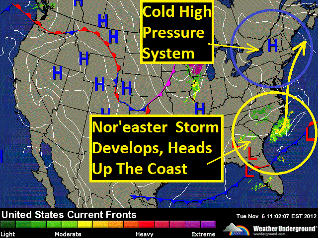
(Cold air in place ahead of a coastal storm)
Chilly temperatures are greeting many across the Northeast this election day thanks to a cool high pressure system sitting over the region. Expect high temperatures generally in the 40s for most of the region, with 30s into northern New England. Despite the cold temperatures, this system of high pressure is also producing fair weather for today for the entire region with partly cloudy to mostly sunny skies. For tonight, mostly clear skies will prevail as that high pressure system stays in place, this will allow temperatures to dip into the 20s across much of the region, with 30s along the coast from Boston down to Philly. As we head into Wednesday, fair weather will continue over the Great Lakes, however we'll be monitoring our next weather maker making its way into the picture that will be affecting coastal communities along the Midatlantic and southern New England. A strengthening storm will ride up the eastern seaboard from coastal North Carolina to the Midatlantic on Wednesday. This system is expected to rapidly intensify off the Midatlantic coast from Wednesday evening into early Thursday morning producing heavy precipitation and strong gusty winds for some of the same coastal areas already ravished by Hurricane Sandy one week ago. Winds could gust up and over 50 miles per hour along the immediate coast on Wednesday night from the Jersey Shore to Long Island to Cape Cod. Precipitation will start off as rain Wednesday afternoon initially.
( Rain to start, mixing with snow and sleet overnight Wednesday)
Then depending on the track of this storm as it comes up the coast, there could be enough cold air dragged in on the back side of the storm to produce a mix of rain wet snow and sleet Wednesday night and early Thursday morning with a light accumulation from New Jersey to western Long Island including New York City, up to western Connecticut, western Massachusetts, southern Vermont and New Hampshire, to Maine. A slight change in the storm track would change this forecast considerably. If the storm track closer to the coast precipitation would remain in the form of rain for these areas, with any frozen precipitation pushing further inland. Temperature wise, we can expect the chilly temperatures to stick around for the next few days before a brief warm up heads our way this weekend, with some temperature readings in the 60s returning to the picture on Sunday.
Saturday, November 3, 2012
Saturday, October 27, 2012
Significant Threat to New Jersey, New York City and Long Island

Sunday evening Sandy will begin to turn back to the north, then north west again about 200 miles east of Cape Hatteras. During this time, as Sandy turns more westerly towards land it will begin to join forces with a frontal system that will be moving east toward the coast. From Sunday evening through Monday, this frontal system will become stationary, and then begin to literally absorb a vast amount of tropical moisture associated with Sandy in a virtual tug of war between systems.This will form a large swath of very heavy rain covering over the Midatlantic and southern New England.

Because many trees have begun to lose their leaves, storm drains and sewers will become blocked by these fallen leaves. This will lead to urban flash flooding especially in those flood prone areas. As Sandy gets absorbed by this frontal system it will undergo a metamorphosis, losing its tropical characteristics and becoming more of a larger hybrid type of storm, something like a super Nor'Easter with tropical storm forced winds extending out an extraordinary 400 to 500 miles in diameter with embedded hurricane forced wind gusts.

This hybrid storm is expected to make landfall somewhere over in the Midatlantic between the Delmarva Peninsula and the Jersey Shore on Monday with sustained winds up and over 70 miles per hour. This will have dire repercussions for coastal communities from: The Chesapeake Bay, to the Jersey Shore, to Long Island, to Cape Cod as the ingredients for major coastal inundations are becoming apparent.

These ingredients include: prolonged easterly winds up to tropical storm force, storm surge associated with Sandy, higher than normal tides expected during Monday's full moon, as well as heavy rain; the combination of these factors could potentially, at worst, rearrange coast lines carving out new inlets and new barrier islands. This storm will also have a wintery side as cold air gets dragged into the rear flank of the storm. This could produce a heavy wet snowfall over the higher elevations of the Appalachians in the Virginas and extreme eastern North Carolina. Wide spread power outages that will last for several days can be expected for millions of residents from North Carolina to Long Island due to the nature of this storm.

This storm could wind up totaling up and over $1 Billion in damages when its all said and done, having both a big economic and human toll. Like Hurricane Irene last year evacuation orders will likely be in effect for low lying zones of New York City making this the second time in history the city has issued evacuation orders due to weather. This storm will be nothing to sneeze at as tidal flooding could surpass what was experienced with Irene last year and Hurricane Floyd in 1999.
Subscribe to:
Posts (Atom)


