
Wednesday, June 8, 2011


Sunday, May 15, 2011
Rain Sticks Around 5/15/11

Rain will continue in earnest this week. A low pressure system is moving ever so slowly through the Northeast. Inundations are expected as the flooding rains stick around through Thursday putting a damper on outdoor plans. The weather should improve by this weekend as this system finally pulls out of the region.
Monday, May 2, 2011
Weather synopsis: Monday May 2

(Click Image To Enlarge)
4:20pm a cold front draped over the Appalachians provided the cloudy weather over the Northeast today. Ahead of the front temperatures climbed through the 60s. Behind the front temperatures where held down into the 40s and 50s by low clouds and drizzle. On Tuesday, a storm system will ride north along this frontal boundary towards the Northeast. This will produce a steady rain generally to the west of the Appalachians over the Great Lakes; however precipitation should hold off along the Atlantic with the exception of a few pop up thunderstorms during the evening. Tuesday's temperatures will vary greatly depending on which side of the cold front you are situated. Ahead of the frontal boundary temperatures will soar well into the 70s approaching 80 degrees Fahrenheit in some cases along the Atlantic seaboard. Behind the cold front temperatures will once again be held down by clouds and rain barely pushing 50 degrees over western New York State and the Great Lakes. The cold front will push through the entire region on Wednesday increasing the chance of showers for the entire Northeast. Conditions should improve by Thursday, expect more sunshine than clouds to start with temperatures approaching 60 degrees. Mostly cloudy skies on Friday will give way to partly-to-mostly sunny skies on Saturday. It should turn out to be a pleasant spring day on Saturday, great baseball weather with temperatures once again hoovering around the 60 degree mark.
Sunday, April 17, 2011
Weather synopsis: Sunday April 17

(Click Image To Enlarge)
11:31am cold air today rushing in over the unfrozen Great Lakes has produced a light wintry mix of wet snow, sleet and rain downwind of Lake Erie with less than 1" of accumulations expected - meanwhile more tranquil and milder weather can be found along the Atlantic seaboard with temperatures approaching 60 degrees. Winds have been a factor today over the Northeast today gusting over 50 miles per hour. Chilly conditions will linger across the interior Northeast as we head into Monday with another chance of a quick burst of rain and snow over the Great Lakes - conditions along the Atlantic coast should remain mild and tranquil. The next big chance of precipitation will arrive Tuesday into Wednesday. Temperatures should moderate on Wednesday approaching 60 degrees, though it will be mild, there could be enough instability in the atmosphere to produce embedded thunderstorms. Temperature will cool off after Wednesday - this will be especially true over the Great Lakes on Thursday as temperatures fall back into the 40s for day time Highs, it should remain mild though away from the Great Lakes along the Atlantic coast with temperatures in the 60s.
Friday, April 15, 2011
Weather synopsis: Friday April 15


(Click Image To Enlarge)
12:54pm a pleasant Friday afternoon is greeting the Northeast today. Temperatures today will run just a degree or two below the average for today's date. A dome of high pressure over the Canadian province of Quebec is responsible for the brilliant sunshine today over the Northeastern US. This will be short lived as the next storm system begins to impact the region late this evening, rain will reach the coast by Saturday. A soaking, heavy rain is anticipated with the onset of this system putting a damper on most Saturday outdoor activities. Behind this system, colder air will rush in over the unfrozen Great Lakes- a light wintry mix of wet snow and sleet could fall Saturday night into Sunday downwind of Lakes Erie. The extended outlook calls for moderating temperatures mid next week along with more rain Tuesday.
Wednesday, April 6, 2011
Weather synopsis: Wednesday April 6

12:00am after a long, cold and snowy winter the Northeast is finally about to catch a nice break from the big chill beginning this weekend. First we will have to get through the rest of the week. The phrase "April showers" rings true as yet another rain maker looms on the horizon. Partly to mostly cloudy skies are forecast on Wednesday and Thursday along with a scattered shower - high temperatures will range in the 40s on Wednesday and 50s on Thursday. Then a storm system moves into the region on Friday with a threat of more heavy rain, at the moment I think this system will pass just far enough to the south that it should spare us from the brunt of the precipitation. After this storm moves out, a warm air mass will surge into the Northeast. High temperatures on Saturday could approach the 60s and warmer still on Sunday easily breaking 70 degrees, I think that it could end up being even warmer than that, its gonna feel like summer on Sunday. There could be some scattered pop-up thunderstorms on Sunday. Another warm day is forecast for Monday, with more scattered thunderstorms likely across western New York State as the next storm system reaches the western fringes of the Northeast.
Tuesday, April 5, 2011

Saturday, April 2, 2011
Weather synopsis: Saturday April 2

10:07am April is not fooling around, opening up with a Nor'easter that produced heavy rain, snow and strong winds across the region. That storm has departed the Northeast but April is just getting started. We can expect marginally warmer temperatures as well as more heavy rain this month beginning early this week - a storm system charging eastward this up coming week will produce unsettled weather on Monday and Tuesday over the Northeast. There could be enough instability in the atmosphere to produce a squall line of thunderstorms across the region. This storm system will move out quickly, temperatures will range in the 40s ans 50s during the middle of the week with partly to mostly cloudy skies. After this first storm system early next week, the next chance of precipitation will arrive during the later portion of next week, likely in the form of heavy rain and thunderstorms.
Wednesday, March 30, 2011


Tuesday, March 29, 2011

Sunday, March 27, 2011
Weather synopsis: Sunday March 27
12:31pm the Northeast has dodged a bullet this weekend as a storm system passes to the south of the region. A streak of fair but cool weather will continue for the early part of this week, high temperatures will range in the 30s and 40s. Unsettled weather is forecast to return late this week. Rain and snow showers are in the forecast on Thursday. I am monitoring a potential coastal storm possible on Friday and Saturday to affect the Northeastern seaboard. We are still days away from this weekend, a better forecast will be made available as the time frame approaches.
Monday, March 21, 2011
Weather synopsis: Monday March 21

(Click Image To Enlarge)
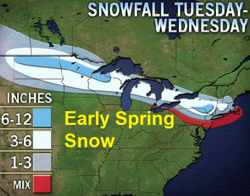
6:16pm our premature Spring fever has come to an end, the battle between winter cold and spring warmth continues with the on set of another cold snap that will influence our temperatures through the rest of this week. Along with cooler temperatures, a threat for a rain and snow mixture looms over the Northeast beginning late Tuesday night over western New York and spreading east on Wednesday. Buffalo could pick up between 3" to as much as 8" of wet snow - 1-3" of wet, slushy snow is possible along the coast around the city of New York as well before the storm moves away early on Thursday. Behind this storm system temperatures will be rather chilly - highs ranging in the 30s and 40s with lingering snow flurries on Thursday night. Fair but cold weather will be with us on Friday and Saturday, it will be a good time for traveling. The rest of the weekend looks to remain chilly, I am monitoring the potential for another storm system early next week that could produce more flooding rain and/or snow for the region around Sunday and next Monday, hopefully this system stays far enough south to spare the region. The extended forecast calls for a prolonged period of chilly weather as High Pressure over Canada allow for cold air to flow into the Northeast.
Thursday, March 17, 2011
Weather synopsis: Thursday March 17

Happy St. Patrick's Day!
11:11pm cooler winds are blowing across the Northeast as a cold front makes an early appearance on Friday afternoon. High temperatures will range in the 40s and 50s across western and upstate New York and northern New England, with the exception of the Northeastern seaboard - here temperatures will rise into the 60s and 70s with mostly sunny skies ahead of an approaching cold front. The weekend looks fair; highs will range in the 40s and 50s. The next chance of precipitation will arrive on Monday and Tuesday as more rain showers will begin to affect the region.
Wednesday, March 16, 2011
Weather synopsis: Wednesday March 16

11:39pm fair weather will reconquer the region on Thursday - ample sun shine is in the forecast with afternoon high temperatures soaring well into the 50's and 60's. It will fell like spring on Friday with daytime high temperatures climbing into the 60's and 70's. Brilliant sun shine is expected on Friday for most of the Northeast with the exception of a few hit and miss showers over the eastern Great Lakes and northern New England. Then it looks like slightly cooler temperatures will try to work their way back in to the Northeast on Saturday and Sunday.
Tuesday, March 15, 2011
Weather synopsys: Tuesday March 15

(Click Image To Enlarge)
11:11pm after a pleasant start to the work week another storm system will bring more unsettled conditions to the flood stricken Northeast. This quick moving storm system should cool temperatures down slightly on Wednesday with a chilly rain before the noon hour. Precipitation will be heaviest towards the coast as there could be embedded thunder storms with in the showers. The storm system will move out just as fast as it came in as fair weather reconquers the region on Thursday - ample sun shine is in the forecast with afternoon high temperatures soaring well into the 50's and 60's. It will fell like spring on Friday with daytime high temperatures climbing into the 60's and 70's. Brilliant sun shine is expected on Friday for most of the Northeast with the exception of a few hit and miss showers over the eastern Great Lakes and northern New England. Then it looks like slightly cooler temperatures will try to work their way back in to the Northeast on Saturday and Sunday.
Saturday, March 12, 2011
Wednesday, March 9, 2011
Weather synopsis: Wednesday March 9

6:24pm unsettled weather is affecting the region once again, heavy rain will promt concerenes of flooding for portions of the Northeast. Rain will continue on Thurday as a storm system progresses east towards the coast. Unsettled conditions are expected to continue on Friday with the heaviest precipitation reaching the coast overnight Thursday and early morning Friday. Behind this system there will be a chillier air mass that will try and infiltrate the region. This should produce light snow flurries and snow showers over the Great Lakes this weekend with improving conditions elsewhere in the Northeast beyond Saturday. Beyond the weekend, my extended forecast calls for another pleasent start to the work week with fair weather and average temperatures.
Saturday, March 5, 2011
Weather synopsis: Saturday March 5

(Click Image To Enlarge)
5:44pm Rain will reach the Atlantic late Sunday evening, a cold front will trail the precipitation and colder air will rush in behind the front changing rain to snow before ending over interior sections of the region on Sunday - Buffalo could see between 2 inches to as much as 8" of snow by Sunday afternoon, precipitation will remain in the form of rain along the coast and will be heavy at times with embedded thunderstorms possible. Rain will come down in buckets especially on Sunday night from the Jersey Shore to southern New England. After this storm departs by Monday morning cloudy skies will give way to mostly sunny conditions. The extended forecast calls for chili conditions during the first half of next week however it wont be as cold as we have been this winter, temperatures will range in the 30s and 40s with fair weather through the middle of the week until the next storm system begins to impact the region around Wednesday and Thursday.
Friday, March 4, 2011
Weather synopsis: Friday March 4

(Click Image To Enlarge)
10:10pm rain will spread the Northeast region this weekend. Rain has already started to fall in western portions of the region including Buffalo, NY. Rain will spread east this weekend and will reach the Atlantic by late Sunday evening. A cold front will trail the precipitation this weekend, colder air will rush in behind the front changing rain to snow before ending over interior sections of the region on Sunday - Buffalo could pick up a quick 2" of snow by Sunday afternoon, precipitation will remain in the form of rain along the coast. The extended forecast calls for chili conditions during the first half of next week however it wont be cold, temperatures will range in the 30s and 40s with fair weather through the middle of the week until the next storm system begins to impact the region around Wednesday.
Wednesday, March 2, 2011

Thursday, February 24, 2011
Weather synopsis: Thursday February 24

(Click Image To Enlarge)
11:11pm a powerful storm system will plow through the region on Friday, this system will produce heavy rain and strong winds gusting over 40 miles per hour along the coast with heavy snow further inland. Snowfall rates of up to 2" per hour are likely over western New York State during the height of the storm between 7:00am through 2:00pm. Snow accumulations will range between 4" to as much as one foot in Buffalo. Along with the heavy snow, winds gusting to 35 miles per hour will drop visibilities to around a 1/4 mile or less producing white out conditions. During this same time frame, heavy rain will affect the Atlantic coast. Combined with a deep snow pack, rain could create issues of urban and small stream flooding. Strong winds will also be an issue. Wind gust of up to 60 miles per hour could knock down trees and cause wide spread damage. Precipitation will subside in the evening.
Monday, February 21, 2011
Weather synopsis: Monday February 21

8:35pm The extended forecast calls for a continuation of the cold weather this week, forecast highs will be in the 20s and 30s through out the week - though it will be cold, a High Pressure system will produce clear skies thus the higher angle of the sun as we come closer towards spring will produce a brilliant sunshine during the daytime through the middle of the week. High temperatures will reach the 40s on Thursday. Then another storm system will be in the works late in the week. The cyclone genesis of this storm is yet to be determined - nevertheless, this next system may bring more Ice, snow and wind to the Northeast late this week on Friday and Saturday.
Sunday, February 20, 2011
Weather synopsis: Sunday February 20

12:14pm a winter storm will affect the Northeast tonight and tomorrow. This storm system will produce a heavy snowfall across interior portions of the Northeast this evening into Monday morning - snow will mix with rain and sleet along the coast on Monday limiting snow accumulations. 3-6" of snow is possible in Buffalo by Monday Morning with lesser amounts as you head towards the Atlantic seaboard ~2-5" expected in and around New York City. The extended forecast calls for a continuation of the cold weather this week, forecast highs will be in the 20s and 30s through out the week - though it will be cold, a High Pressure system will produce clear skies thus the higher angle of the sun as we come closer towards spring will produce a brilliant sunshine during the daytime through the middle of the week. High temperatures will reach the 40s on Thursday. Then another storm system will be in the works late in the week. The cyclone genesis of this storm is yet to be determined - nevertheless, this next system may bring more Ice, snow and wind to the Northeast late this week on Friday and Saturday.
Thursday, February 17, 2011
Weather synopsis: Thursday February 17
11:11am mild temperatures have made their way into the Northeast; one more mild day is in the forecast for Friday but then its back to reality as winter stikes back.
Friday, February 11, 2011
Weather synopsis: February 11 & 14

இڿڰۣ-ڰۣ—Happy-Valentines-Dayஇڿڰۣ-ڰۣ—
11:11am needless to say, it's been a bone chilling cold week thanks to this latest intrusion of arctic air. Temperatures remained between 10-20° below where we should be this time of the year. Along with the frigid temperatures, winds inexcess of 40 miles per hour made it feel well below zero. There is good news for the winter weary - finally there is a warm up on the way after Valentines Day. First we have to get through another clipper system that produced more light snow over the Great Lakes and Northern New England - this clipper will keep the cold temperatures around for a time but not for long. A mass of relatively warmer air will advance northward this upcoming week that will expel northward the dense cold air mass which has gripped the Northeast for the better part of this winter. This week our temperatures will climb into the 30s and 40s early next week in the Northeast with 50s and 60s or better not out of the question during the latter portion of the week; it is definitely going to feel like spring. Look, I'm not saying that we are done with winter, keep in mind - it's only mid-February, there is still one more month of Winter to contend with. Nevertheless, the prolonged cold spell of below average temperatures over the Northeast will fall apart - temperatures over the next several weeks will oscillate between alternating cold and warm periods. I guess the groundhog - Punxsutawney Phil was right, spring might make an early entrance, but keep in mind - it's only mid-February. Historically speaking, late February and early March are notorious for big Northeast winter storms. Enjoy the warmth but don't put away the shovels and snow melts just yet.
Saturday, February 5, 2011
Weather synopsis: Saturday February 5

5:08pm more rain and snow will continue through the evening. The greatest accumulations will be associated with an upper level low pressure system moving over the Northeast this evening changing rain back to snow, an additional 2-4 inches is likely across western New York - little to no accumulations expected along the coast. A wicked cold arctic air mass will visit the Northeast this week that could set the stage for another storm along the coast - forecast models are in disagreement in regards to the cyclone genesis and track of this potential storm system late next week but one thing is almost certain, it will be cold. Temperatures will bottom out once again this week as frigid air streams into the region on Monday and Tuesday lasting through the week, single digit cold and subzero lows are likely with this next invasion of arctic air. Good news for those starked by old man winter, long range temperature projections indicate that a warm air mass with above average temperatures my try to push into the Northeast for a time after Valentines Day.
Friday, February 4, 2011
Weather synopsis: Friday February 4

(Click Image To Enlarge)
12:44pm another storm is in the forecast for the Northeast on Saturday. This storm will move northeastward and produce a swath of precipitation - predominantly closer to the coast. Light rain, snow and sleet will fall through the day on Saturday in New York City with light snow further inland. Snow flurries could make it all the way in to Buffalo with little to no accumulations. Then, the upper level low feature associated with this storm will produce a light, but steadier snowfall during the late evening hours on Saturday over New York City. Snowfall totals should be minimal between 1-4 inches. After this weekend's storm, two more storms will affect the Northeast, the latter of which could turn into a big Nor'Easter late next week. Temperatures will actually moderate by a few degrees early in the week - then another arctic air mass will infiltrate the region behind a cold front on Tuesday, this will set the stage for the potential Nor'Easter later on during the week. It is too early to forecast the precise impact this system will have on the Northeast, however; forecast models are indicating a strengthening system moving up the eastern sea board around the Thursday time frame.
Wednesday, February 2, 2011
Weather synopsis: Wednesday February 2


(Click Image To Enlarge)
10:05am our big winter storm is still amongst us however, the bark was bigger than the bite. The storm system began to break apart this morning during the time that the heaviest precipitation was forecast to fall. Additionally, sleet and snow pellets began to mix in with the snow as a temperature inversion aloft allowed warmer air to come in to the upper atmosphere with temperatures below freezing at the surface. Snow accumulations have ranged between 3" and 6" in and around the grater Buffalo area with another 1-2 inches on the way towards the afternoon hours. Up to 2" of snow and nearly 1/2 inch of ice has fallen over New York City, now the precipitation has changed to plain rain causing concerns of street flooding as we get some melting of the snow pack. I hate to sound like a broken record but another storm is on the way for this weekend, this next system looks like it will be a coastal storm. The exact track this storm will take as it rides up the coast is uncertain at this point but it does appear as if warmer air will be involved with this system right along the coast with cold air staying further inland. More details will be made available as we approach the weekend. Today is Groundhog Day and the famous Punxsutawney Phil did not see his shadow predicting an early end to the winter and early arrival of Spring.
Sunday, January 30, 2011
Weather synopsys: Sunday January 30


(Click Image To Enlarge)
5:35pm a major winter storm is brewing promising heavy snow and ice across much of the country including the Northeast from Monday night through Wednesday. This storm system will create thunder snow along with near blizzard conditions in Buffalo on Wednesday morning during the height of this storm with heavy rain and or ice south of the NY/PA boarder including coastal sections of the Northeast and Midatlantic. Initially, snow will break out late on Monday night and will continue through Tuesday - this first round of precipitation will produce a general 3"-6" snow accumulations through the Northeast from Buffalo to Long Island. Then precipitation will begin to tapper off to light snow on Tuesday evening; snow will begin to mix with freezing rain and sleet early morning on Wednesday south of the NY/PA boarder and along the coast. The storm's peak impact on the region will be felt during the morning hours on Wednesday lasting through early afternoon before dissipating late in the evening. Total snow accumulations in Buffalo, NY will likely exceed 15 inches and locally over 20 inches due to the high snowfall rates with this storm - when you factor in wind gust in excess of 30 miles per hour we're looking at a good chance of a bonnafied blizzard in Buffalo during the morning rush. The forecast gets more complicated as you head towards the coast as warm air south of the storm track will mean a variety of precipitation - we could be dealing with a period of significant icing in New York City before the precipitation changes over to rain late Wednesday morning. The exact track this storm will take as it heads east is not set in stone, a deviation to the south will mean less snow in Buffalo and colder temperatures along the coast yielding heavier snow in New York City. Regardless, this storm will have a major impact over the region with massive disruptions and delays possible.
Saturday, January 29, 2011
Weather synopsis: Saturday January 29

(Click Image To Enlarge)
3:29pm good news for all of us snow lovers, the forecast calls for yet another big storm as we head in the the middle of the week. A cold arctic air mass continues its grip over much of the northern-tier of the nation, this will open up a southern storm track. A storm system will move east from the Rocky Mountains producing a wide spread heavy snowfall across the country all the way to the Atlantic. Heavy snow is likely over the Northeast on Wednesday as the storm system begins to affect the region, significant snow accumulations are expected in Chicago, Illinois then east to Buffalo, NY. Heavy precipitation will also make its way into the megalopolis on Wednesday however, the storm system may pull in enough warm air off the Atlantic Ocean to change the heavy snow to an icy mix and rain before changing back to snow towards the end of the storm, it is still too early to determine the exact track of this system, which will determine the temperature variations and precipitation type. Nevertheless, another major winter storm is likely to affect the region beginning from late Wednesday morning with the heaviest precipitation through out the afternoon hours - significant snow accumulations of 6 inches or greater will be common through out a large area of the country on Groundhogs Day. In the words of former New York Yankee catcher and manager Yogi Berra "It's deja vu all over again".
Subscribe to:
Posts (Atom)


