U.S. National Radar

Comet Ison Viewing Guide

Thursday, January 27, 2011

Weather synopsis: Thursday January 27


(Click Image To Enlarge)
6:02pm the northeastern seaboard recovers from yet another major snow storm. This has been the 7th storm system to affect the region since Christmas just over one month ago. January 2011 now officially holds the new record for the snowiest month of all time at Central Park in New York City at just over 36". The snow storm delivered a one two punch on Wednesday, the first round of precipitation came in almost unexpectedly; the surface low pressure feature of the storm produced a mass of heavy precipitation that traversed from south west to the north east ranging between 3-6 inches of snow along the coast in a short period of time, this created a messy morning commute for the big cities from Washington to New York. As the precipitation intensity began to subside around the mid-afternoon the storms counter clockwise circulation drew in warmer air off the Atlantic mixing snow with sleet and rain, then all rain for a brief period. Then towards the evening, the upper level low pressure feature of this storm reintroduced cold air aloft - this, in combination with the intensity of the precipitation nearly 2-4" of snow per hour! during the height of the storm late Wednesday and early Thursday produced over 1 foot of additional snow accumulation in a short period. Snowfall totals for the duration of the storm ranged between 1 foot over central Long Island to 19 inches in New York City. Along with the intense precipitation, the convective activity associated with this storm also produced numerous lightning and thunder reports as well as strong and gusty winds in excess of 40 miles per hour in most cases. The storm has now moved into the Canadian maritime as is no longer a concern for the region, however, there is still more snow on the horizon. A series of clipper systems will begin to affect the region on Friday then again on Saturday. These clipper systems will move quickly and produce about 2 inches of additional snow on Friday then another 2 inches on Saturday. These storm systems will also enhance Lake Effect Snow producing 4-8 inches of snow accumulation along the Great Lakes. Temperatures will be on the down swing,getting progressively colder over the weekend and early next week as more arctic air spews into the Northeast. The long range projections indicate a continuation of this cold and snowy weather pattern for the next few weeks with another possible big snow storm around groundhogs day.

Wednesday, January 26, 2011

Weather synopsis: Wednesday January 26


(Click Image to Enlarge)
1:00pm this snow storm has arrived sooner than anticipated creating a messy morning commute over much of the northeastern seaboard. The intensity of the precipitation resulted in snow accumulations around and about 3 to 5 inches in a short period of time during the late morning rush hour; this created big problems in the big cities from Washington and Baltimore to Philadelphia then north to New York City. Doppler Radar idicates there could be a brief break from the heavy precipitation as the storm system tries to pull in warmer air on towards the coast from the Jersey shore to Long Island. During this time, snow will mix with sleet and perhaps change to rain. Then this evening, heavy precipitation will start again with another 5 to 8 inches of additional accumulation and near blizzard conditions likely especially over Long Island. Winds will gust between 30 and 40 miles per hour during the height of this storm along the coast late Wednesday and early Thursday combined with 1 to 3 inch per hour snowfall rates will result in poor visibilities down to a 1/4 mile or less. The storm should be over and done by 6:00am with improving conditions through Thursday. Behind this storm system temperatures will gradually trend towards colder through the weekend. The next storm system that will affect the region is not too far behind and will approach the Northeast this weekend. This next storm will be a weaker system dipping down from central Canada affecting the entire Northeast with minor snow accumulations making the roads slick once again, behind this next system an even colder air mass will begin to over take the region once again early next week.

Monday, January 24, 2011

Weather synopsis: Monday January 24


10:02pm boy was it a cold one this morning. Low temperatures dropped close to -10 degrees below zero in Buffalo. This is an extensively cold air mass covering the entire Northeast region down to the north Atlantic coast; Low temperatures in the Bronx, NY dipped to 4 degrees on Sunday night and Monday morning with single digit temperatures extending east over Long Island. Our temperatures will moderate into the 30's, though still cold its certainly more manageable than this past weekend's brutal temperatures. Along with the cold we will have to contend with more wintry precipitation. First we have a weak upper level low pressure system over the Great Lakes enhancing Lake Effect Snow, this will produce a light snow on Tuesday with little accumulations if any over the Northeast. The real big player in our weather will occur over the middle of the week as a strengthening low pressure system moves up the east coast. This system will be a difficult one to forecast. Initially, I though this would be a wind whipped snow event along the coast; however as this storm system tracks north east ward, it strengthens pulling in Atlantic moisture, enough so that is will moderate temperatures right along the coast. The result will be a sloppy mixture of rain, snow and sleet with strong gusty winds. Initially, a light snow will break out - quickly mixing with sleet on Wednesday Night. The sleet will mix with and perhaps change to rain through midnight which could be heavy at times melting some of the snow pack, after midnight cold air will start to work its way back down to the coast. This will change the rain back to snow. The timing of these temperature variations along with the forecast track of this coastal storm will determine the type of impact this storm will have on the region. I think that once the precipitation changes back to snow along the coast Wednesday night and early Thursday morning we could get up to 6 inches of snow accumulations by the time its all said and done. Behind this system more cold air looms, particularly by late next weekend when another blast of brutally cold air is likely.

Friday, January 21, 2011

Weather synopsis: Friday January 21


4:20pm a very cold, polar air mass is taking up residence over the Northeast this weekend bringing with it subzero temperatures to our region. This is the coldest air mass to hit the region since January of 2010. High temperatures in Buffalo will be around 5 degrees above zero this weekend with Lows dipping down to around -10°F. It will be cold all the way down to the north Atlantic coast; High temperatures in New York City will be in the teens with Lows on Sunday dropping down to around zero degrees, when you factor in the wind it will feel much colder with wind chill values below zero. The cold air will stick around for the weeks and perhaps months ahead, the weather pattern in place will allow for a continuation of streams of cold air to spill into the Northeast. What does the weather hold for the next few days you ask? Well you guessed it right, my forecast calls for more cold and snow to impact the region. The next weather maker will be a weak low pressure system that will sweep through the Northeast on Saturday, this will produce some minor Lake Effect Snows down wind from the Great Lakes with some snow flurries elsewhere in the Northeast. Then by the middle of the upcoming week we could be dealing with a major snow storm similar to the Christmas weekend blizzard from the Chesapeake Bay up the coast to coastal Canada. At the moment, the latest forecast models are in agreement that this potential Nor'Easter will take shape - however, the timing and the impacts of this storm system is still in question. As of right now, I think that the storm will hit the Northeast some time on Wednesday - this storm does have the potential to produce an impressive wind driven snowfall along the coast.

Thursday, January 20, 2011

Weather synopsis: Thursday January 20


8:35pm a true arctic dose of uber (super) cold air is spilling in to the Northeast; the forecast calls for temperatures to plummet. Temperatures have been running at or below average for the winter so far and they are likely to get even colder in the days ahead. A cold air mass over the polar region will spew a blast of cold air aimed at the Northeast. Ahead of this mass of cold air, a storm system will zip across the region this evening into the day on Friday spreading a wide area of accumulating snow. The heaviest snow will be confined to locations down wind of the Great Lakes as well as the immediate coast from the Jersey shore to the Gulf of Maine - 6 inches or more of snow is likely. At its peak, snowfall rates will be around 1 to 3 inches per hour between 6 and 10 in the morning . I'm talking about white out conditions just in time for the morning rush in New York City. The snow should tapper off by Noon time in New York City, Lake Effect snow will continue through the evening around the Great Lakes. Behind this system we will see temperatures drop like a rock. High temperatures on Friday will be in the 10's and 20's. Temperatures will get even colder this weekend; High temperatures will be hard pressed to rise above zero degrees in Buffalo. Temperatures will drop to zero degrees in New York City overnight on Saturday and Sunday. When you factor in the wind temperatures will feel much colder. Dress in layers when venturing out this weekend making sure to cover exposed skin surfaces as frost bite can settle in pretty fast during prolonged exposure to extreme cold. Also, it might be a good idea to make sure you top off you gas tanks with a full tank.

Monday, January 17, 2011

Weather synopsis: Monday January 17


11:57pm a complex storm system is moving in to the region. The warm air associated with this system will try to over ride a layer of cold arctic air that has been in place since January 1st. The result is a sloppy mixture of frozen precipitation. Snow will mix with sleet and freezing rain through the early morning on Tuesday before becoming all rain by late morning. Snow could accumulate 1-3 inches before the messy mixture of rain and icy precipitation take over. The storm system will swiftly move out of the region by early evening on Tuesday. Right on the heels of this storm system I am monitoring yet another potential snow storm for the latter part of this work week on Friday; current forecast models agree that this next storm system could produce another significant snowfall for the Northeast followed by a deep arctic blast. Long range weather projections predict that the current weather pattern will be prolonged at least through mid February. We can expect a continuation of this cold and stormy pattern with several opportunities for snow storms. It might be a good idea to invest in a warm winter hat, a pair of gloves and boots.

Friday, January 14, 2011

Weather synopsis: Friday January 14


2:05pm despite sounding like a broken record, once more we are talking about the firm grip of a cold air mass that has been with us since the New Year. The forecast calls for the cold air to continue as a series of weak low pressure systems comming in from central Canada will progreesively reinforce the cold air already in place. One of these weak low pressure systems will be the next weather maker over the Northeast this weekend. A clipper type system will move in to the Northeast by way of the Great Lakes on Saturday, this will initiate some Lake Enhanced Snow with accumulations ranging between 2-4 inches in Buffalo. This weak system will also produce some light snow and flurries for the rest of the region through Sunday with little to no snow accumulations expected. Behind this system a reinforcing shot of arctic air will keep our temperatures where they have been if not slightly colder. Looking ahead into next week, I am monitoring the potential for a disruptive storm system that could affect the region on Tuesday and Wednesday with a mixed bag of precipitation. It is too early to indicate the exact details of this storm's impact on the region; more information will be available as the projected time frame approaches.

Tuesday, January 11, 2011

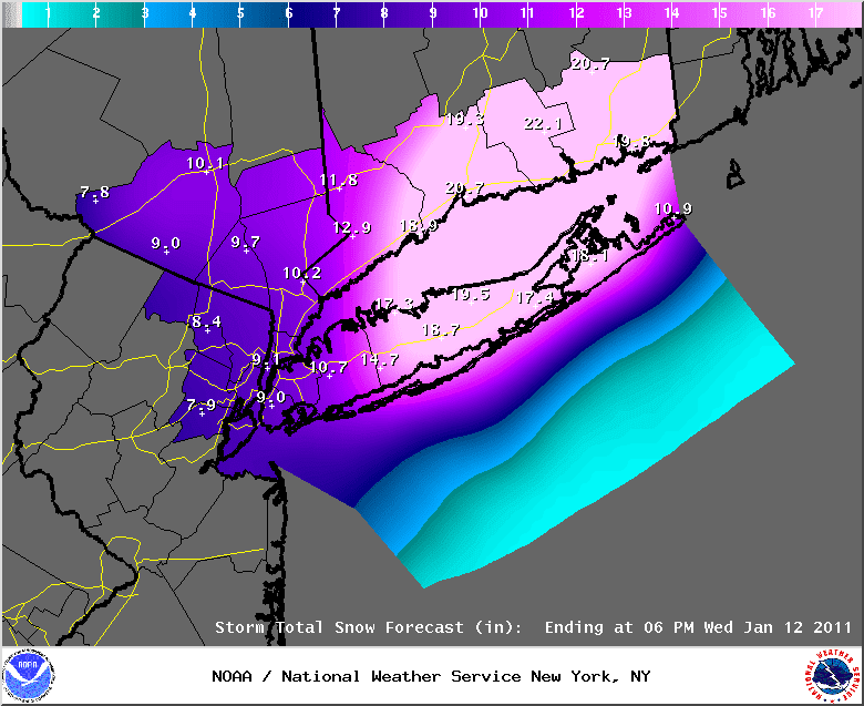
NYC Metro Updated Snowfall Forecast


(Click Image To Enlarge)
4:20pm a Nor'Easter will produce a decent amount of snow over the region. Snow accumulations between 6 inches to 1 foot is likely in and around the greater New York City metropolitan area. It looks as if this storm will be an over achiever in terms of snow accumulations specifically over central and eastern Long Island where accumulations could whind up in the 20 inches range with locally higher amounts. Blizzard conditions will also be likely over Long Island and on in to Connecticut and Rhode Island; winds will begin to howl as this storm system deepens producing a virtual blizzard over these areas.

Monday, January 10, 2011

Weather synopsis: Monday January 10


8:41pm a classic Nor'Easter is in the making with its eyes targeting the region once again. There are several atmospheric factors in play working to produce this storm which has yet to develop. Once the gears set in to motion, this system will likely have an impact over the entire Northeast. First, we have been under a cold spell since the beginning of the year; this will be the primary ingredient for a winter storm as this cold air mass will support frozen precipitation through out the duration of this event. There have been two storm systems traversing the nation, one over the northern Great Plains and the other over the Southeast. These two systems are producing snow and ice over a large area of the country as they progress eastward. The storm over the Southeast will transfer its energy off shore and redevelop in to a coastal storm off the Southeast coast. This coastal low will then shoot up the eastern seaboard and simultaneously, the storm system over the Great Plains will move across into the Northeast; the way in which these two storm system interact and eventually phase off the Northeastern seaboard will determine the formation of this Nor'Easter and it will dictate the impact that will be felt across the region. Here is my forecast: Snow will begin to fall Tuesday afternoon in Buffalo and later Tuesday evening in New York City/ Long Island. Light to moderate snow will fall through the night away from the coast. Snow will become steady and heavy overnight along the coast as our two storm systems phase and become one greater coastal low pressure system between 2:00am and 8:00am; it is within this time period is where I think the worst of the storm will affect New York City and Long Island. Snowfall rates of 1-2 inches per hour will be likely in the Tristate area. The snow intensity will begin to diminish after 8:00am with snow showers lingering through the noon hour before ending after noon. In terms of snow accumulations, the majority of Northeast will have a general snowfall between 3-6 inches including the city of Buffalo. Snow accumulations will tend to be greatest as you approach the coast. In the five boroughs and Long Island I'm calling for 6 to 12 inches with locally higher amounts. The greatest amounts of snow will be out over eastern Long Island where the majority of the moisture associated with this system will be confined, I expect snow totals over 1 foot in localized areas. White out conditions are also expected within the 1-2 inch per hour snow bands. Along with heavy snow, winds will be gusty as this storm system deepens off the coast of New England. Keep in mind that any deviation in the storms forecast track and intensity could mean a more significant storm for the New Jersey, New York and Connecticut corridor.

Saturday, January 8, 2011

Weather synopsis: Saturday January 8


11:55am the snowy pattern continues today as a broad upper level low continues to pinwheel storm after storm through the Northeast. On Friday, a band of snow produced a general 1" to 4" snowfall in the five boroughs of NYC yesterday with as much as 6" of snow in northeastern New Jersey and up to 12" in parts of Connecticut. The snow was most persistent once it passed to the east of New York confining the heaviest accumulations to Long Island and Connecticut. Today, another round of snow will sweep through the area and will produce an additional 1" of snow in NYC with up to 5" of snow as you head east towards the eastern end of Long Island. Snow will also be an issue around Buffalo as the Lake Effect continues, an additional 1-3 inches of snow are possible by tonight. Looking ahead, there is still a chance of another more powerful storm system to affect the Northeastern seaboard. At this time, I don't think that this next storm will affect the New York City metro area. The more likely scenario is that once this potential storm system develops Tuesday evening is will track up the coast; it looks as if the majority of moisture associated with this low pressure system will remain off shore, sparing the Tristate from another blizzard. As with any potential coastal storm, we are still days away from this scenario. Any deviation in this storms track as it heads up the coast could change the forecast significantly.

Thursday, January 6, 2011

Weather synopsis: Thursday January 6


5:00pm today marks the 15th anniversary of the notorious Blizzard of 1996, which bombarded the Northeast with record snow and strong winds from North Carolina to Massachusetts. So far this winter we have already had a heck of a snow storm erily comparable to the 1996 Blizzard back in December during the Christmas weekend. Flash forward to 2011; the weather is promising more arctic cold and snow to infiltrate the region as we enter a cold and stormy weather pattern. First, Lake Effect Snow is cranking up once more as a weak disturbance moves over the Great Lakes this evening. An additional 3 to 6 inches is likely in Buffalo beginning tonight and lingering through the next few days. The same low pressure system that will enhance Lake Effect Snow in northern and western New York State will eventually move off the coast of Long Island early Friday morning. This weak system will strengthen as it gathers energy from the Atlantic Ocean and will produce a wide spread area of accumulating snow. Like I mentioned in my previous posting, I don't think that this will be any where near as impressive as the Christmas weekend Nor'Easter. My forecast calls for a narrow band of snow that will develop along a trough as this system works its way off shore. Snow will break out in the tristate area during the morning hours on Friday and will persist through the evening hours before dissipating to flurries very early on Saturday. Generally between 4 inches to as much as 10 inches of snow is likely in and around the New York City metropolitan area, the greatest accumulations will be confined to areas where this snow band is most persistent. Snowfall rates of 1 to 2 inches per hour is possible at the peak of this storm. Beyond this weekend, the weather seems to remain active with the likelihood of yet another more powerful storm in the horizon during the middle potion of next week. I will be monitoring the situation and will continue to post updates on a regular basis.

Tuesday, January 4, 2011

Weather synopsis: Tuesday January 4


8:16pm cold conditions prevail over much of the country as an arctic flow makes its presences evident in the continental United States. Currently over the Northeast we are dealing with a weak low pressure system that has originated over central Canada. This system will be moving over the Great Lakes this evening and is responsible for enhancing some of the Lake Effect Snow we've been dealing with around the city of Buffalo were accumulations have ranged between 4-8 inches since January 1. The Lake Effect Snow should become more disorganized as we progress through Wednesday as this weak clipper system moves away from the region. Behind this system, another shot of arctic air will reinforce the cold air mass that is already in place. Later this week, another weak clipper system will move into the Northeast once again initiating some Lake Enhanced Snow showers on Thursday and Friday. This same low pressure system will move off the Mid-Atlantic coast on Friday; there will be a chance for this system to morph in to another coastal storm. This developing system could gather energy from the Atlantic Ocean and intensify. I have been monitoring this situations for a few days and it seems as if forecast models agree that there will be a potential snow storm to affect portions of the Northeast Friday and Saturday. As per the current computer model data, I think this potential storm system will produce accumulating snow from New York City northward along the coast. Right now I don't think that this will be a Blockbuster type snow storm in New York City like we saw during the Christmas weekend blizzard; if this storm materializes the heaviest snow should generally stay to the east of the big apple and confined to Long Island, Connecticut and southern New England. However, this storm is still days away and a slight deviation in the projected track and intensity will mean the difference between a snowless weekend and a mammoth snow storm of similar proportions to the Christmas weekend Nor'easter.

Saturday, January 1, 2011

Weather synopsis: Saturday January 1


Happy New Year!
5:36pm the transition into the new year brought along mild temperatures over much of the region. Temperatures climbed to near 60 degrees in Buffalo earlier on January 1st which aided in the melting of much of the snow pack. This mild streak will be short lived as a sharp cold front works its way eastward. Ahead of this frontal boundary, temperatures will soar in to the 50s with intermittent rain showers. Tonight this cold front will begin to sweep the region, the cold air mass behind this front will drop temperatures quite rapidly by a factor of 30 degrees. Tonight's forecast low temperatures in Buffalo are expected to dip in to the lower to middle 20s, this will create hazardous conditions as a flash freeze will over take the region. Any puddles from the rain and melt water will turn in to a solid sheet of black ice. Untreated surfaces will pose a threat to pedestrians and motorist alike. Exercise caution when venturing out as icy conditions are likely. The chance for Lake Effect Snow flurries will become increasingly likely as this cold air mass flows over the relatively unfrozen lake Erie. This cold snap will be enduring as wave after wave of arctic air reinforces the air mass that will be settling in.

Friday, December 31, 2010

2010: A Look Back At The Wild Year In Weather


11:11am 2010 turned out to be a year of weather extremes for the entire world, not only was it the warmest meteorological year on record world wide, the end of the year was also the coldest and snowiest November and December ever on record for Europe. The 2010 Atlantic Hurricane season was the 3rd most active Hurricane Season on record with 19 named tropical systems developing in the Atlantic basin. And do you recall the majors headlines of this year? The magnitude 8.8 Earthquake that struck Chile in February was the strongest quake ever recorded on Earth. The magnitude 7.2 Earthquake that struck Haiti in January brought upheaval to its people and focused world attention on the devastation. The extreme monsoon flooding in Pakistan during the summer was the worst modern natural disaster, directly affecting 200 million people. The eruption of the Iceland Volcano Eyjafjallajokull in April was responsible for the worst civil aviation breakdown since World War 2. And even here with in the continental United States, we've had our fair share of extremes. The big daddy of environmental disaster, the Deepwater Horizon Oil Spill in the Gulf of Mexico spewed 205.8 million gallons of crude oil in to the ocean non stop from April to September shutting down the economy of the Gulf of Mexico States. The "Snowmagedon" that unleashed storm after storm over the Northeast in early 2010 buried cities under an unprecedented amount of snow from Virginia to Long Island with snowfall totals for the season exceeding 80 inches in Philadelphia and Baltimore, surpassing the snowfall amounts in Buffalo for that season. The summer of 2010 will be remembered for the series of deadly heat waves that affected the entire world; All-time record highs were set in over a dozen countries in Africa, the Middle East, and parts of Asia. Record warmth ravished the continental United States with many cities surpassing their longest streak of 90 degrees or better by a significant margin. In Russia, this was the worst heatwave in 1000 years with many cities reaching 100 degrees for the first time since records have been kept. In Moscow the heat produced a thick chocking smog due to the combination of the heat and air pollution, doubling the mortality rate. Last but certainly not least was the Christmas weekend Blizzard that affected over 80 million people in the eastern United States and virtually paralyzed the city of New York for days after the storm.

Tuesday, December 28, 2010

Christmas Weekend Nor'Easter Recap

The New York City Metropolitan Area received between 20 inches and 40 inches of snow in less than 24 hours in a Nor'Easter that paralyzed the Big Apple. All area airports were shutdown for over 12 hours, airlines canceled over 5,000 flights leaving thousands of passengers stranded for days. The storm forced Amtrak to cancel all service between NYC and Boston and caused massive delays in the New York City subway system, Some people were stuck in subway trains for up to 11 hours. Emergency response crews could not get to 911 calls due to the city's poor management during the blizzard, streets remained unplowed for up to 3 days after the storm. This Nor'Easter is one for the records; winds were gusting to near 80 miles per hour in many coastal areas during the height of the storm; numerous reports of thunder and lightning were widely scattered throughout the area. A minimum central pressure of 965 millibars was recorded at the center of circulation, this is equivalent to a category 2 Hurricane. This storm came in at #6 in New York City's long list of major snow storms since records began.


Saturday, December 25, 2010

Weather synopsis: Saturday December 25


Merry Christmas!
12:50pm the National Weather Service has issued a slew of winter storm watches and warnings up and down the Atlantic coast in anticipation of a Nor'easter that is expected to impact the region with strong winds and significant snowfall. The combination of heavy snow along with strong gusty winds will produce blizzard conditions for many areas including Long Island and eastern New England; I expect blizzard conditions to impact New York City and coastal New Jersey as well. A low pressure system over the Gulf of Mexico states will move east towards the Atlantic coast this evening. This low pressure system will strengthen off the coast of the Carolinas and then stream northward parallel to the east coast. With cold air already in place, the moisture associated with this storm system will produce a swath of heavy snow from the Carolinas to Maine. I expect this storm system to further intensify on its track up the coast; this will whip-up the winds right along the coast producing white out conditions and a bonafied blizzard for many. Snow will develop in New York City and Long Island from around noon time through early afternoon on Sunday. The snow will get steady and heavy during the late evening with the heaviest precipitation arriving during the overnight and lasting through the early morning hours on Monday. It is during this time frame when I expect the blizzard to be in full force for the New York City metropolitan area as winds will gust up and over 50 miles per hour. Snowfall totals will range between 8 inches to 1 foot from the Jersey shore to Long Island with many locations receiving well over 1 foot of snow. Snow will continue to fly through Monday morning before ending from southwest to the northeast as this storm system moves away from the region on Monday afternoon and evening. This Nor'easter will have a major impact on travel plans especially for area Airports as visibilities will go down to 1/4 mile or less for a good period of time. Many airlines have already canceled flight in anticipation of the snow that could pose a threat of icing. Road conditions will deteriorate rather quickly once the heavy snow and strong winds begin to impact the region on Sunday evening.

Thursday, December 23, 2010

Weather synopsis: Thursday December 23


10:43pm a cold air mass continues to have a firm grip over the Northeast. Areas of light snow have been impacting coastal regions of the Northeast, these snow flurries are associated with the outer bands of a broad area of low pressure off the coast of New England. No snow accumulation is expected with this system however, I have been monitoring the potential for a significant snowfall to impact the coast this weekend into early next week. A storm system that has been inundating the Southwestern states will make its way across the country through the course of this week. This system will produce a swath of accumulating snow for the Midwest, severe thunder storms for the South and icy conditions for places in between. This mess of precipitation will work its way eastward by Christmas Day producing snow as far south as Atlanta; then a secondary area of low pressure will redevelop off the Southeast coast and depending on the track of this storm system we could have a messy situation in the Northeast on Sunday and Monday. This is a preliminary forecast that is subject to change based on new computer model data: A light snowfall will break out over New York City and Long Island during the afternoon hours on Sunday. The snow will get steadier overnight with the heaviest snow expected early Monday morning before tapering off Monday afternoon and evening. Snowfall totals will increase from west to east with the greatest amounts over Long Island and eastern New England. Generally between 6 inches to as much as 12 inches is certainly possible from this system, however, if the track of this storm veers just 50 miles to the east or west it could mean the difference between no snow to well over 1 foot of snow over the targeted areas. This potential Nor'easter is still days away and I reiterate, this is a preliminary forecast that is subject to change as the time frame approaches.

Sunday, December 19, 2010

Weather synopsis: Sunday December 19

6:20pm the interstate 95 corridor along the Northeast has dodged a bullet as a potential Nor'easter has veered coarse taking a path further out in to the Atlantic Ocean than what computer models had anticipated earlier this week. This track will spare the big cities from a significant snow accumulation this time around. Several rounds of snow are possible this week for the entire Northeast as a series of clipper systems make their way from central regions of Canada down to the eastern United States with the potential for a big snow storm on Christmas Day. This weather pattern will continue to enforce the cold that is in place keeping our High temperatures in the 20s and 30s through the week. This week a rare astronomical event will stake place, not only will the winter solstice take place on Tuesday December 21 but, on that same day there will be a Lunar eclipse at approximately 3:15am. According to NASA, the last time that a Lunar eclipse occurred during a winter solstice was in the year 1638 over 370 years ago. Cloudy skies and Lake Effects Snow will likely obscure the eclipse along the Great Lakes. Better chances of observing the eclipse will be away from the lakes and generally south of New England.

Monday, December 13, 2010

Weather synopsis: Monday December 13


8:18pm bitterly cold air temperatures along with strong and gusty winds are making it feel like an ice box across the Northeast. A storm system that impacted the region with milder temperatures and heavy rain this weekend has pulled away; in the wake of this storm system the coldest air mass since last January has infiltrated the Northeast, enough instability will be present to produce some light snow along the coast through early afternoon on Tuesday. Temperatures are running between 15 and 20 degrees below normal for this time of the year. The cold and wind over the relatively warmer waters of the Great Lakes are producing Lake Effect Snow over western New York State, western Pennsylvania and northeastern Ohio. Winter weather watches and warnings for Lake Effect Snow are in effect for most locations down wind of the lakes. A Lake Effect Snow warning is in effect for Buffalo until 6am Wednesday morning, between 10 and 16 inches of snow is expected with higher amounts south of Buffalo as well as regions down wind of Lake Ontario from Rochester to Syracuse where up to 3 feet of snow is possible. Lake Effect Snow will continue through Wednesday producing localized blizzard conditions along the New York State Thruway from Buffalo to Syracuse. The Lake Effect Snow should come to an end by Thursday and a period of tranquil weather will prevail through the upcoming weekend. Computer models are indicating that on Sunday December 19th a low pressure system could develop a long the Northeast coast. Depending on the cyclone genesis of this potential system, we could be dealing with a Nor'easter for the big cities of the Northeast from Washington to New York and Boston.

Sunday, December 5, 2010

Weather synopsis: Sunday December 5


11:59pm a bitterly cold arctic air mass continues to spew in from central Canada. High temperatures will run 10 to 15 degrees below normal across the Northeast. This week, day time high temperatures will remain in the 30s along the coast with 20s for the interior. To add insult to injury, winds will make it feel much colder. Wind gust of up to 45 miles per hour will make it feel 10 to 20 degrees colder over New York City and Long Island. A persistent stream of cold air over the Great Lakes will produce several days of Lake Effect Snow. A slew of Lake Effect Snow alerts are in effect down wind of the lakes. The potential exist for a solid 1 to 2 feet of snow along the south shores of Lake Ontario from northern Niagara County eastward through Rochester and Syracuse. Buffalo should receive and additional 5 to 10 inches of snow by Tuesday morning with locally higher amounts, while south of the Greater Buffalo metropolitan area, Chautauqua County and Cattaraugus County between 2 to 3 feet of snow is likely. Lake Effect Snow can be expected through Tuesday before tapering off to scattered flurries Tuesday night; however, more Lake Effect Snow is on the horizon beyond Tuesday. Another round of impressive Lake Effect Snow will arrive late this week. As this cold air mass settles in and we progress through the deep freeze of winter, the jet stream will be oriented in a manner that is favorable for a "blockbuster type snow storm" for the entire Northeast - computer models are indicating that in the days and weeks to come it is very well possible to have 1 or 2 storm systems develop which could bring big snows along the coast from New England to the Midatlantic. Its beginning to look and feel a lot like Christmas, by December 25th it is likely we could have a white Christmas for nearly 50% of the entire continental United States.

Tuesday, November 30, 2010

Weather synopsis: Tuesday November 30


4:20pm a soaking rain is prompting concerns of flooding all along the Northeast as a storm system continues to creep in to the region. Along with the threat of floods, this system will likely produce severe thunderstorms on Wednesday along the coast. Expect heavy rain and strong winds to continue through the evening, The National Weather service has issued a wind advisory in effect Wednesday morning which includes New York City and Long Island; here, winds could gust up to 50 miles per hour. This storm system will continue to slowly move east on Wednesday, behind this storm a cold air mass will rush in to the region. Rain will mix with and eventually change over to snow across the interior Northeast. This provides a good indication of how cold it will be after this storm moves on by. On Tuesday temperatures are running in the upper 50s to around 60 degrees; on Wednesday behind the cold front, temperatures will run in the 30s and 40s. Accumulating snow is possible on Wednesday evening in Buffalo as the rain changes to snow, by Wednesday night between 1 and 3 inches of snow is possible here. Then from Wednesday night through Thursday Lake Effect Snow could develop producing additional snow accumulations down wind of Lake Erie and Lake Ontario. The National Weather Service has issued a Lake Effect Snow Watch in effect from Wednesday evening through Thursday which includes the city of Buffalo. At this time, the most persistent snowfall is forecast to stay just south of Buffalo, however it is possible that this squall of Lake Effect Snow will be over Buffalo for a time producing a few inches of additional accumulation. Looking ahead, there is speculation that this weekend and beyond could host the coldest air mass since last winter with a good opportunity for snow across the entire Northeast next week, more details as the time frame approaches.

Sunday, November 28, 2010

Weather synopsis: Sunday November 28


12:20pm a dome of High Pressure is dominating the weather across the east producing generally fair weather from Maine to Florida. Temperatures are forecast to moderate today and tomorrow, this should melt most of the snow from this weekend's Lake Effect. Reports of generally 2 to 4 inches of snow came in from Buffalo with higher amounts south of the city on the order of 5 inches to well over 1 foot. There will be a lull in the weather through Monday ahead of the next storm system, this next low pressure system will affect enter the Northeast on Tuesday bringing heavy rain and possible severe thunderstorms. By Wednesday, a cold air mass will rush in behind this system and will likely change the rain to snow before ending on Wednesday evening from Buffalo to Long Island. The cyclonic flow (counter clock wise) around this low pressure system will orient the winds over the Great Lakes and will likely initiate another round of Lake Effect Snow along the snow belt Wednesday through Thursday. Snowfall accumulations could be heavy in localized areas downwind of the lakes. Looking ahead in to the first weekend of December and beyond, forecast models are hinting towards the development of a storm system that could affect a good portion of the Northeast with heavy wind driven snow; it is still too early to say whether or not this will transpire, I will continue to monitor this situation as the time frame approaches.

Friday, November 26, 2010

Weather synopsis: Friday November 26


11:11am The National Weather Service has issued a Lake Effect Snow Warning for counties down wind of Lake Erie which includes the city of Buffalo. The Lake Erie snow machine will spring to life for the first time this season. Cold, strong and gusty winds blowing over the relatively warm waters of the lake will initiate a narrow band of Lake Effect Snow that will affect western New York from Friday afternoon through Saturday morning. This band of snow will likely produce a period of heavy snow from Buffalo southward. Locations where this band of snow is most persistent will likely see 1 to 2 feet of snow before it is all said and done; at this time, the greatest accumulations are expected to hit the southern suburbs of Buffalo (Dunkirk, Hamburg, Fredonia). The city of Buffalo its self is not out of the picture. This band of snow will produce snow fall rates of 2 to 3 inches of accumulation per hour; the snow squall will be over Downtown Buffalo from 7:00pm this evening thorough the early morning hours on Saturday. Snow totals in Buffalo could range between 5 inches to 1 foot by Saturday with the highest accumulations toward Downtown. Lesser amounts of snow can be expected as you head northward away from Buffalo, conversely, greater amounts of snow is likely south of Buffalo. Along with the snow, winds will be gusting up and over 45 miler per hour. This will cause near white out conditions at times due to blowing and drifting snow. The worst of the weather will hit Buffalo this evening and will linger though the very early morning on Saturday before diminishing through Saturday afternoon. Elsewhere across the Northeast, a storm system will be moving through producing showers of rain. In the wake of this system temperatures will once again take a tumble with highs around 40 degrees Fahrenheit on Saturday with clear skies along the coast.

Wednesday, November 24, 2010

Weather synopsis: Wednesday November 24


7:10pm a shift in the predominant weather pattern is underway for the eastern portion of the nation. Temperatures have dropped nearly 20 degrees since yesterday as a cold air mass continues to spill into the region. A storm system will be moving in on Thanks Giving day; precipitation will break out in the form of rain along the coast with pockets of freezing rain, sleet and snow across the interior valleys of the Northeast including portions of northern Pennsylvania and the southern tier of western New York State. Snow could mix in with the rain in Buffalo on Thanks Giving day as well. As this storm system passes on by, another shot of cold air will rush in behind it. This will initiate the first significant Lake Effect Snowfall of the season over the eastern shores of Lakes Erie and Ontario. For this reason, the National Weather Service has issued a Lake Effect Snow Watch which includes the city of Buffalo from Friday afternoon through Saturday. Light snow will get steadier from noon time on over the lower Great Lakes region. At this time it is rather early to pinpoint the exact locations that will receive the heaviest of the snow accumulation, the potential exists for up to 2 feet of snow in a localized area with in the most persistent snow bands which appear to be just south of Buffalo and down wind of Lake Ontario. This will be the first accumulating snow across many areas since last winter, this would be a good time to winterize your vehicle in anticipation of a potentially major accumulating snow event in western New York.