U.S. National Radar

Comet Ison Viewing Guide

Monday, July 27, 2015

When to Expect the “Warmest Day of the Year”

During the summer months, many areas in the United States approach their highest temperatures for the year. To give you a better idea of the warmest time of year for your area, NCEI has created these “Warmest Day of the Year” maps for the contiguous United States, Alaska, Hawaii, and Puerto Rico. The maps are derived from the 1981–2010 U.S. Climate Normals, NCEI’s 30-year averages of climatological variables including the average high temperature for every day. From these values scientists can identify which day of the year, on average, has the highest maximum temperature, referred to here as the “warmest day.”

(Click Image To Enlarge)

Although the amount of solar radiation reaching Earth peaks at the summer solstice on June 21 in the Northern Hemisphere, temperatures for most of the United States tend to keep increasing into July. The temperature increase after the solstice occurs because the rate of heat input from the sun during the day continues to be greater than the cooling at night for several weeks, until temperatures start to descend in late July and early August.

But, this isn’t the case everywhere! The “Warmest Day of the Year” maps show just how variable the climate of the United States can be. For instance, the June values in New Mexico and Arizona reflect the North American Monsoon, a period of increased rainfall affecting the U.S. Southwest. Because these areas tend to be cloudier and wetter from July through September, the temperature is highest on average in June. Similarly, the persistence of the marine layer along the Pacific Coast leads to cool temperatures in early summer with the warmest days on average later in the season.

Temperature Normals are important indicators that are used in forecasting and monitoring by many U.S. economic sectors. Knowing the probability of high temperatures can help energy companies prepare for rising electricity demand and help farmers monitor heat-sensitive crops. They are also useful planning tools for the healthcare, construction, and tourism industries. You may want to check the Normals before planning your next event or vacation.

While the map shows warmest days of the year on average throughout the United States, this year’s actual conditions may vary widely based on weather and climate patterns. For prediction of your actual local daily temperature, and to see how it matches up with the Climate Normals, check out your local forecast at Weather.gov.

Wednesday, February 26, 2014

Significant Storm Possible Next Monday - Update Wednesday 2/26/14

This relentless winter continues its grip through this week, and will persist on into next week with more bitter cold and wintry precipitation. Snow this morning will give way to sunshine this afternoon, but it will remain cold with highs below the freezing mark. The cold temperatures will stick through the weekend with some snow flurries possible tomorrow afternoon. The sunshine will return on Friday, but it will be deceiving as it will be bitterly cold with high temperatures struggling to reach the lower 20s.

The next big storm that I will be monitoring will be on Monday, as a storm system will traverse the country and move into the dense arctic air mass in place over the Northeast. The storm will be riding on the southern branch of the jet stream and will bring much needed moisture to the state of California which has been enduring severe drought conditions, however though it will bring some drought relief this system will likely bring the threat of flash flooding and mudslides for Californians.

As this system pushes east, it will produce a slew of dangerous weather on its track ranging from severe thunder storms over the southern states to wintry precipitation over the Midwest and on into New England. As it stands, there is a potential for a significant snow accumulation for our area on Monday March 3rd. We are still several days away from this and better information will be available to fine tune this forecast.

Thursday, February 13, 2014

Tuesday, February 11, 2014

Monday, February 10, 2014

AccuWeather's Bernie Rayno Breaks Down This Weeks Potential Winter Storm 2/11/14


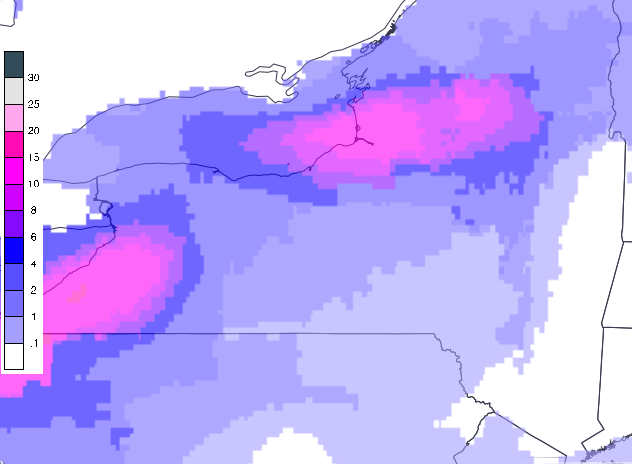
 National Weather Service Projected Snowfall Totals For
Thursday February 13th 2014
(Click Image Above To Expand)

Monday, February 3, 2014

Updated National Weather Service Total Snowfall Forcast

(Click Image Above To Expand)

The National Weather Service has issued a Winter Storm Warning for the Tri-state area, which is in effect until 7pm. A Rain/Snow mix began falling around 4am, and quickly changed over to a wet snow just in time for the morning rush hour. Snow will continue to fall through the early afternoon, and will begin to wind down during the evening rush hour, tapering off before 5pm this evening. As of 12 noon snow accumulations have averaged between 3 and 5 inches so far over Long Island and the five boroughs. An additional 2-4 inches will be likely before the storm pulls away from the area bringing the total snow amounts to 5-9 inches, with lesser amounts as you head north away from the city.

We will see a lull in precipitation during most of the day on Tuesday. However there will be yet another storm system moving into the area during the overnight hours on Tuesday night that is going to produce messy travel conditions on Wednesday. This next system is likely to bring more wintry weather with a potentially significant amount of snow and ice for the Tri-state area. For this reason, the National Weather Service has issued a Winter Storm Watch for Tuesday night into Wednesday.

Sunday, February 2, 2014

Weather Synopsis: Sunday February 2nd 2014

 (Click Image Above To Expand)

This is my first post in about six months, feels good to get back on the weather horse. I could not have picked a more fitting day to return than today, Groundhog Day. Earlier today in the town of Punxsutawney Pennsylvania Americas most famous meteorologist, a groundhog named Phil, has seen his shadow predicting six more weeks of winter. If tomorrows forecast is any testament to the groundhog's prediction then he's right on the mark. The National Weather Service has issued a Winter Weather Advisory for for the Tri-state area where up to 7 inches of snow are possible by tomorrow evening. A storm system will be moving in from the west spreading moisture into the Midatlantic and southern New England. Precipitation will initially fall as a mixture of rain and snow, however there will be just enough cold air in place that the precipitation will fall as a light to moderate wet snow. General snow accumulations will vary by location Expect 1-3 inches along the immediate coast and eastern Long Island, 4-6 inches for central and western Long Island, the five boroughs, and Westchester, and up to 7 inches as you head south and west away from the city. In terms of timing, precipitation will break out around 6 am just in time for the morning rush and gradually pick up in intensity through the early afternoon, ending by the evening rush hour around 5 pm.

Friday, August 9, 2013

Perseid Meteor Shower Peaks August 11 - August 14

Up to 100 meteors per hour can be observed at the height of the Perseid Meteor Shower this weekend into early next week. The best viewing times will be between midnight and sunrise from Sunday night August 11th through sunrise on Wednesday August 14th. If you plan on venturing out to catch the amazing streaks of light you can expect excellent viewing weather in the Northeastern US with clear skies during the optimal viewing times this weekend into early next week. Look to the northeast sky between midnight and sunrise on August 11th through August 14th and you can see up to 100 meteors per hour, that's roughly 1 to 2 meteor per minute or so.


Tuesday, August 6, 2013

Sunday, July 28, 2013

Hurricane Season 2013 Update July 28th: The Remnants of Dorian

What once was Tropical Storm Dorian has come under the influence of strong westerly winds as it moved into the western Atlantic.


Despite moving over warmer waters, the strong wind shear aloft has weakened Dorian, becoming just a cluster of thunderstorms. The remnants  of Dorian will continue on a westward path bringing an elevated risk of tropical rains into the Greater Antilles including Puerto Rico, the island of Hispaniola and Cuba.


Eventually by mid-week if this area of showers and storms holds together it will bring precipitation into souther Florida.

Wednesday, July 24, 2013

Hurricane Season 2013 Update July 24, 2013: Tropical Cyclone Dorian

The fourth named tropical cyclone of the 2013 Atlantic Hurricane Season has formed, and is the first Cape Verde storm of the season. As of 5:00 pm Wednesday evening Tropical Storm Dorian is centered off the coast of Africa to the west of the Cape Verde Islands. The storm is moving towards the West North West with a forward momentum of 20 miles per hour. Max winds are sustained at 50 miles per hour with gusts as high as 65 miles per hour and a minimum central pressure measured at 1002 millibars. The path of Dorian will be determined by a broad region of high pressure over the Atlantic Ocean. The clockwise flow around this high pressure system will provide the steering winds aloft that will continue to guide Dorian westward over the open waters of the Atlantic.


There are a few factors that are in place that will diminish how fast this tropical system strengthens through the course of the week. One of these factors will be the continuing influence of dry and dusty Saharan air that is being spread westward from the African continent by the same steering winds guiding Dorian, generally the influence of dry air keeps tropical systems from strengthening. Another factor that will keep Dorian from rapidly intensifying are the marginally warm waters of the open Atlantic. Tropical systems rely on warm ocean water temperatures in the 80s to rapidly gain strength, Dorian is currently over waters that are barely warm enough to support tropical development with waters in the lower to middle 70s. For the moment, one factor that is favorable for Dorian to at least remain of Tropical Storm intensity is that it is situated in a relatively low wind shear environment for the time being, this means that the storm isn't likely to be torn apart by strong winds aloft. I do expect this system to continue its westward trajectory through this week as a Tropical Storm.


Thereafter Dorian could become more organized as is moves in to warmer waters and threaten the Virgin Islands and Puerto Rico in the timeframe of Sunday and Monday, however the storm could face stronger wind shear that could keep it from strengthening into anything major. I will continue to monitor this situation as it unfolds.

Wednesday, June 26, 2013

Weather Synopsis: Wednesday June 26, 2013

The heat across the Northeast continues today as we brace for yet another 90+ degree day here in the New York City Metropolitan area. Along with the heat the humid air mass in place over the region will also give us the chance for pop-up thunderstorms in the evening.

(Click Image to Enlarge) Courtesy of Accuweather
 The storms will become more wide spread I think overnight tonight, through the day on Thursday and on into Friday as a low pressure system moves into the region from the Ohio river valley. This system of low pressure will make the atmosphere more unstable, this will increase the chance of precipitation in our area through Friday. On the plus side, the increased cloud cover will keep the temperatures at bay in the 80 degree range, however it will still feel rather muggy as this humid air mass continues its grasp over the region. What about the weekend? well its looking muggy and wet, though not a complete washout there is a chance of rain with the greatest chance of precipitation on Sunday.

Monday, June 24, 2013

2013 Atlantic Hurricane Season Outlook


Weather Synopsis: Monday June 24, 2013

The first full week of summer is upon us and right on cue mother nature is responding by turning up the heat. The National Weather Service has issued a Heat Advisory for all of New York City which is in effect through Tuesday. Temperatures today and tomorrow are expected to top off in the lower to middle 90s; when you factor in the humidity, heat indexes will feel more like the upper 90s to 100 degrees. The question, whats causing all this heat?  The answer, a high pressure system off the eastern seaboard over Bermuda; the clockwise flow around this system of high pressure is spewing in a sticky hot and humid air mass from the south.

(Click Image to Expand) Courtesy of Accuweather
This air mass looks like it will be hanging around at least through the rest of the week as this Bermuda High will continue to pump hot and humid air up into the northeast. This heat and humidity will foster an environment favorable for the typical garden variety late day pop up thunderstorms giving us a chance of storms in the evening through the week.

Thursday, June 6, 2013

Hurricane Season 2013: Tropical Cyclone Andrea

Already one week into the start of the 2013 Atlantic hurricane season, which began on June 1st, we have our first named tropical cyclone. As of 11:00 AM Tropical Storm Andrea is centered 160 miles to the east of Tampa moving to northeast at 14 miles per hour with maximum sustained wind speeds of 60 miles per hour gusting up to 70 miles per hour and a minimum central pressure of 997 millibars. Andrea is expected to continue producing heavy rain for the state of Florida along with the threat of isolated tornadoes embedded with in the heavier rain bands.

(Click Image to Expand) Tropical Cyclone Andrea Impacts Florida
The center of circulation is expected to make landfall  to the east of Tallahassee this evening after 5:00 PM eastern time. From there, the storm will weaken loosing its tropical characteristics as it accelerates in forward speed tracking up the east coast producing heavy rain from Georgia to Maine. Heavy rain from what remains of Andrea will impact the New York City metropolitan area on Friday, ending by the early morning hours of Saturday.

(Click Image to Expand) Tropical Cyclone Andrea Projected Storm Track  

Thursday, March 21, 2013