U.S. National Radar

Comet Ison Viewing Guide

Wednesday, March 30, 2011

Tuesday, March 29, 2011

Sunday, March 27, 2011

Weather synopsis: Sunday March 27


12:31pm the Northeast has dodged a bullet this weekend as a storm system passes to the south of the region. A streak of fair but cool weather will continue for the early part of this week, high temperatures will range in the 30s and 40s. Unsettled weather is forecast to return late this week. Rain and snow showers are in the forecast on Thursday. I am monitoring a potential coastal storm possible on Friday and Saturday to affect the Northeastern seaboard. We are still days away from this weekend, a better forecast will be made available as the time frame approaches.

Monday, March 21, 2011

Weather synopsis: Monday March 21


(Click Image To Enlarge)
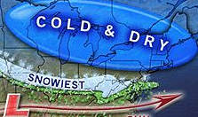
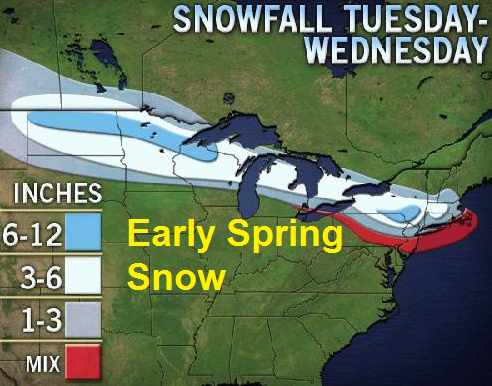
6:16pm our premature Spring fever has come to an end, the battle between winter cold and spring warmth continues with the on set of another cold snap that will influence our temperatures through the rest of this week. Along with cooler temperatures, a threat for a rain and snow mixture looms over the Northeast beginning late Tuesday night over western New York and spreading east on Wednesday. Buffalo could pick up between 3" to as much as 8" of wet snow - 1-3" of wet, slushy snow is possible along the coast around the city of New York as well before the storm moves away early on Thursday. Behind this storm system temperatures will be rather chilly - highs ranging in the 30s and 40s with lingering snow flurries on Thursday night. Fair but cold weather will be with us on Friday and Saturday, it will be a good time for traveling. The rest of the weekend looks to remain chilly, I am monitoring the potential for another storm system early next week that could produce more flooding rain and/or snow for the region around Sunday and next Monday, hopefully this system stays far enough south to spare the region. The extended forecast calls for a prolonged period of chilly weather as High Pressure over Canada allow for cold air to flow into the Northeast.

Thursday, March 17, 2011

Weather synopsis: Thursday March 17


Happy St. Patrick's Day!
11:11pm cooler winds are blowing across the Northeast as a cold front makes an early appearance on Friday afternoon. High temperatures will range in the 40s and 50s across western and upstate New York and northern New England, with the exception of the Northeastern seaboard - here temperatures will rise into the 60s and 70s with mostly sunny skies ahead of an approaching cold front. The weekend looks fair; highs will range in the 40s and 50s. The next chance of precipitation will arrive on Monday and Tuesday as more rain showers will begin to affect the region.

Wednesday, March 16, 2011

Weather synopsis: Wednesday March 16


11:39pm fair weather will reconquer the region on Thursday - ample sun shine is in the forecast with afternoon high temperatures soaring well into the 50's and 60's. It will fell like spring on Friday with daytime high temperatures climbing into the 60's and 70's. Brilliant sun shine is expected on Friday for most of the Northeast with the exception of a few hit and miss showers over the eastern Great Lakes and northern New England. Then it looks like slightly cooler temperatures will try to work their way back in to the Northeast on Saturday and Sunday.

Tuesday, March 15, 2011

Weather synopsys: Tuesday March 15


(Click Image To Enlarge)
11:11pm after a pleasant start to the work week another storm system will bring more unsettled conditions to the flood stricken Northeast. This quick moving storm system should cool temperatures down slightly on Wednesday with a chilly rain before the noon hour. Precipitation will be heaviest towards the coast as there could be embedded thunder storms with in the showers. The storm system will move out just as fast as it came in as fair weather reconquers the region on Thursday - ample sun shine is in the forecast with afternoon high temperatures soaring well into the 50's and 60's. It will fell like spring on Friday with daytime high temperatures climbing into the 60's and 70's. Brilliant sun shine is expected on Friday for most of the Northeast with the exception of a few hit and miss showers over the eastern Great Lakes and northern New England. Then it looks like slightly cooler temperatures will try to work their way back in to the Northeast on Saturday and Sunday.

Wednesday, March 9, 2011

Weather synopsis: Wednesday March 9


6:24pm unsettled weather is affecting the region once again, heavy rain will promt concerenes of flooding for portions of the Northeast. Rain will continue on Thurday as a storm system progresses east towards the coast. Unsettled conditions are expected to continue on Friday with the heaviest precipitation reaching the coast overnight Thursday and early morning Friday. Behind this system there will be a chillier air mass that will try and infiltrate the region. This should produce light snow flurries and snow showers over the Great Lakes this weekend with improving conditions elsewhere in the Northeast beyond Saturday. Beyond the weekend, my extended forecast calls for another pleasent start to the work week with fair weather and average temperatures.

Saturday, March 5, 2011

Weather synopsis: Saturday March 5


(Click Image To Enlarge)
5:44pm Rain will reach the Atlantic late Sunday evening, a cold front will trail the precipitation and colder air will rush in behind the front changing rain to snow before ending over interior sections of the region on Sunday - Buffalo could see between 2 inches to as much as 8" of snow by Sunday afternoon, precipitation will remain in the form of rain along the coast and will be heavy at times with embedded thunderstorms possible. Rain will come down in buckets especially on Sunday night from the Jersey Shore to southern New England. After this storm departs by Monday morning cloudy skies will give way to mostly sunny conditions. The extended forecast calls for chili conditions during the first half of next week however it wont be as cold as we have been this winter, temperatures will range in the 30s and 40s with fair weather through the middle of the week until the next storm system begins to impact the region around Wednesday and Thursday.

Friday, March 4, 2011

Weather synopsis: Friday March 4


(Click Image To Enlarge)
10:10pm rain will spread the Northeast region this weekend. Rain has already started to fall in western portions of the region including Buffalo, NY. Rain will spread east this weekend and will reach the Atlantic by late Sunday evening. A cold front will trail the precipitation this weekend, colder air will rush in behind the front changing rain to snow before ending over interior sections of the region on Sunday - Buffalo could pick up a quick 2" of snow by Sunday afternoon, precipitation will remain in the form of rain along the coast. The extended forecast calls for chili conditions during the first half of next week however it wont be cold, temperatures will range in the 30s and 40s with fair weather through the middle of the week until the next storm system begins to impact the region around Wednesday.