U.S. National Radar

Comet Ison Viewing Guide

Tuesday, August 31, 2010

Weather Synopsis: Hurricane Earl Up Date August 31


3:13pm Hazy, hot and humid conditions prevail all over the Northeastern United States. Temperatures are soaring well in to the 90's up and down the east coast from Bangor, Maine to Baltimore, Maryland. The high heat is attributed to a strong High Pressure System at the upper levels of the atmosphere stationed right over the eastern third of the nation. The heat wave will continue through Thursday before a rather strong cold front moves in from the west and drives this dome of High Pressure out to sea. The cold front is expected to usher in much cooler and more pleasant temperatures in to the Northeast in time for Labor Day weekend. In addition, this frontal boundary will be pivotal in determining the exact track of Hurricane Earl. As of 2:00pm eastern time the National Hurricane Center has tracked Earl approximately 120 nautical miles to the north of the Dominican Republic moving towards the west north west with a forward speed of 13 miles per hour. Maximum sustained wind have been recorded at 135 miles per hour making Hurricane Earl a powerful Category 4 storm. The current forecast brings the center of the storm off shore right along the east coast. NCEP forecast models suggest that Hurricane Earl will pick up froward momentum and zip northward into the Canadian province of Nova Scottia. Between now and then residents along the eastern seaboard need to keep a watchful eye on the unfolding situation; there is a chance that Hurricane Earl will make land fall over the east coast late this week Thursday through Friday. A strong cold front is expected to plow through the region. The strong jet stream behind this cold front is forecast to steer Hurricane Earl to the north and then eventually to the north east away from land sparing the east coast from the worst of Hurricane Earl; however, if this cold front moves slower than anticipated the High Pressure system that is currently producing the heat wave over the Northeast will steer Hurricane Earl closer to the coast and potentially bring it right on shore in a worst case scenario situation. If the worst case scenario transpires we could be dealing with a historic life changing event affecting millions of people along the densely populated Northeast. Conversely, if the upper level winds steer Earl away from the coast the Northeast will be spared from the brunt of the storm, regardless of what transpires we will still have to deal with high swells potentially 20 feet or better, significant beach erosion and coastal flooding through out the Labor Day weekend. At this moment Hurricane Earl is not expected to make a land fall in the United States; however, the exact track of this storm is still uncertain. The weather is very dynamic and a forecast can change with out notice, it would not be a bad idea to start preparing now for a worst case scenario. Have and emergency plan for evacuating.

Monday, August 30, 2010

Hurricane Season 2010: Hurricane Earl Update August 30


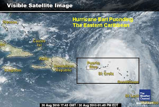
3:00pm Hurricane Earl has been pounding the eastern Caribbean with hurricane force winds and torrential rains. As of 3:00pm the National Hurricane Center tracked the center of Hurricane Earl just north of the British Virgin Islands. The storm is moving towards the west north west with a forward speed of 15 miles per hour. Maximum sustained winds have been recorded at 125 miles per hour making this a major Hurricane at Category 3. Minimum central pressure at the core of the storm has been recorded at 955 millibars and dropping, this persistent drop in central pressure indicates that Earl is strengthening. The current forecast suggests Hurricane Earl will continue to intensify through Wednesday into a powerful Category 4 storm. The exact track of Hurricane Earl is still uncertain; at this time NCEP forecast models are predicting that the Hurricane will track away from the coast. However the system is still days away from the eastern seaboard and a slight variation in the track could potentially bring a major Hurricane on shore this by the end of this week from the outer banks of North Carolina north to Cape Cod including Long Island, the Jersey Shore and the Delmarva Peninsula. Even if Hurricane Earl stays well away from the coast, it will still be close enough to produce significant beach erosion, very high swells and dangerous rip currents.

Sunday, August 29, 2010

Hurricane Season 2010: Update August 29


So far this years Hurricane Season has produced an above average number of systems in the Atlantic. Things are have just began to fire up as we approach the peak of the Hurricane Season. So far there have been 7 Tropical Depressions in the Atlantic of which 5 have gain tropical storm status or better. A tropical storm is considered to be a low pressure system with a closed circulation down at the surface over warm tropical waters with wind speeds of 39 miles per hour or greater. Once wind speeds reach 74 miles per hour the storm is classified as a Category 1 Hurricane. So far this year there have been 3 Hurricanes, The first was Hurricane Alex which formed early in the season and made landfall in northern Mexico near the Texas boarder with maximum sustained winds of 100 miles per hour as a strong Category 2 Hurricane. Hurricane Danielle formed on August 21st from a tropical wave off the African coast and quickly became the first major Hurricane of the Atlantic Hurricane Season as a Category 4 with maximum sustained winds of 135 miles per hour; Danielle has produced some swells and rip currents for the east coast of the United States, the Hurricane is now well east of the island of Bermuda and the forecast calls for this system to continue its track away from the United Stated. The third Hurricane of the season is Hurricane Earl. Like Hurricane Danielle, Earl formed as a tropical wave off the African coast and is now churning the waters of the Atlantic Ocean. The current forecast is driving this strengthening storm towards the eastern Caribbean islands. Tropical Storm and Hurricane advisories have been implemented for the northern leeward islands including the US and British Virgin Islands and Puerto Rico. As of 5:00pm Hurricane Earl has sustained winds of 85 miles per hour and is moving to the west north west at 14 miles per hour. These locations are in the direct path of Hurricane Earl and will likely experience Hurricane conditions tonight and tomorrow. The Hurricane is centered just to the east of the lesser Antilles and will impact the region with Hurricane force winds, torrential rain and high storm surge. Furthermore, Hurricane Earl is forecast to pass dangerously close to the east coast of the United States this up coming weekend during the Labor Day holiday. It is still too early to pin point the exact path of the Hurricane. A frontal boundary is forecast to sweep through the eastern US, the forecast if for Hurricane Earl to be carried by this frontal boundary and make a turn to the north then eventually northeast tracking away from the eastern sea board. Nevertheless, if the storm veers to the west of the forecast track we would be talking about a potential for Hurricane conditions from the Carolina coast up to Cape Cod including Long Island, the Jersey Shore and the Delmarva Peninsula. If the storm stays away from the east coast major impacts will be significant beach erosion, large swells and dangerous rip currents. At this point the forecast is uncertain however we are only a few days away from Hurricane Earl's approach to the east coast.